
Flemish Brabant facts for kids
Quick facts for kids Flemish Brabant (Dutch: Vlaams-BrabantFrench: Brabant flamand) |
|||
| Province of Belgium | |||
 Leuven Town Hall.
|
|||
|
|||
| Country | |||
|---|---|---|---|
| Region | |||
| Capital | Leuven | ||
| - coordinates | 50°53′N 04°42′E / 50.883°N 4.700°E | ||
| Highest point | Walshoutem | ||
| - location | Landen, Leuven, Flemish Brabant | ||
| - elevation | 137.33 m (451 ft) | ||
| Area | 2,106 km² (813 sq mi) | ||
| Population | 1,129,849 (1 January 2017) | ||
| Density | 536 /km² (1,388 /sq mi) | ||
| Subdivisions | 2 Arrondissements 65 Municipalities |
||
| Governor | Lode De Witte | ||
| Timezone | CET (UTC+1) | ||
| - summer (DST) | CEST (UTC+2) | ||
| Postal codes | 1500-1999 / 3000–3499 | ||
| ISO 3166-2 | BE-VBR | ||


Flemish Brabant (in Dutch: Vlaams-Brabant, in French: Brabant flamand) is the newest and smallest province in the Flemish Region of Belgium. It covers the northern part of the old province of Brabant, where people speak Dutch. Flemish Brabant completely surrounds the Brussels-Capital Region, which is like an island within the province.
The capital city, and also the largest city in the province, is Leuven. Leuven is a famous university city.
Contents
History of Flemish Brabant
The name Flemish Brabant means it's part of the Flemish area of the older province of Brabant in Belgium. Brabant was a historic region, once known as the Duchy of Brabant. The name Brabant first appeared in the 600s. It was mentioned when an abbey was built in a place called pagus Bracbatensis. A pagus was a small settlement or district back then.
Flemish Brabant was created in 1995. This happened when the old province of Brabant was split into three parts. These parts were two new provinces, Flemish Brabant and Walloon Brabant, and the Brussels-Capital Region. This split helped to organize Belgium into its three main regions: Flanders, Wallonia, and the Brussels-Capital Region.
Geography and Landscape
Flemish Brabant shares borders with several other Belgian provinces. Clockwise from the north, these are Antwerp, Limburg, Liège, Walloon Brabant, Hainaut, and East Flanders.
The province covers an area of about 2,106 square kilometers (813 square miles). It stretches about 90 kilometers (56 miles) from east to west. From north to south, it is about 40 kilometers (25 miles) wide.
Flemish Brabant is home to over 1 million people. This means it has a population density of about 519 people per square kilometer. The main rivers flowing through the province are the Dyle, the Demer, and the Zenne.
How Flemish Brabant is Organized
The province of Flemish Brabant is divided into two main areas called districts (or arrondissements). These districts help manage the different parts of the province.
Halle-Vilvoorde District
The first district is Halle-Vilvoorde. This area surrounds Brussels. Because of its location, it has many homes and residential areas. It also has large industrial zones where many businesses operate.
Leuven District
The second district is Leuven. This district is centered around the city of Leuven, which is the capital of the province.
The province has 65 smaller areas called municipalities. Each municipality is a local government area.


Population Growth by District
This table shows how the population in each district has changed over several years. It helps us see how many people live in each part of Flemish Brabant.
| Arrondissement | 2007 | 2008 | 2009 | 2010 | 2011 | 2012 |
|---|---|---|---|---|---|---|
| Hal-Vilvorde | 580,407 | 584,416 | 588,743 | 593,455 | 598,944 | 604,097 |
| Leuven | 472,060 | 475,816 | 480,095 | 483,469 | 487,502 | 490,654 |
| Province of Flemish Brabant | 1,052,467 | 1,060,232 | 1,068,838 | 1,076,924 | 1,086,446 | 1,094,751 |
Images for kids
-
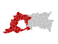
Map showing the location of the Arrondissement of Halle-Vilvoorde

See also
 In Spanish: Provincia del Brabante Flamenco para niños
