
Walloon Brabant facts for kids
Quick facts for kids Walloon Brabant (French: Brabant wallon) |
|||
| Province of Belgium | |||
 The church of St John the Baptist in Wavre.
|
|||
|
|||
| Country | |||
|---|---|---|---|
| Region | |||
| Capital | Wavre | ||
| - coordinates | 50°43′N 4°36′E / 50.717°N 4.600°E | ||
| Highest point | Unnamed point in Trou-du-Bois | ||
| - location | Genappe, Nivelles, Walloon Brabant | ||
| - elevation | 170 m (558 ft) | ||
| Area | 1,091 km² (421 sq mi) | ||
| Population | 399,123 (1 January 2017) | ||
| Density | 366 /km² (948 /sq mi) | ||
| Subdivisions | 1 Arrondissement 27 Municipalities |
||
| Governor | Gilles Mahieu | ||
| Timezone | CET (UTC+1) | ||
| - summer (DST) | CEST (UTC+2) | ||
| Postal codes | 1300-1499 | ||
| ISO 3166-2 | BE-WBR | ||


Walloon Brabant is a province in Belgium. It's one of the five provinces that make up Wallonia, which is the southern part of Belgium where people mostly speak French. Its name in French is Brabant wallon.
Contents
History of Walloon Brabant
What Does "Walloon Brabant" Mean?
The word "Walloon" in Walloon Brabant tells us that this area is part of Wallonia. Wallonia is the French-speaking region of Belgium.
"Brabant" comes from an old region called the Duchy of Brabant. The name "Brabant" was first used in the 600s. It appeared when a monastery was built in a place called pagus Bracbatensis. A pagus was a small town with only a few houses.
How Walloon Brabant Was Created
Walloon Brabant is the newest and smallest province in Belgium. It was created in 1995. Before that, there was one big province called Brabant.
This old province was split into three parts based on language:
- A Flemish (Dutch-speaking) part, which became Flemish Brabant.
- A Walloon (French-speaking) part, which became Walloon Brabant.
- The Brussels-Capital Region, which is now its own special region and not part of any province.
Geography of Walloon Brabant
Size and Landscape
The province of Walloon Brabant covers an area of about 1,090 square kilometers (421 square miles). It's a very flat area.
The highest point in the province is near Genappe. It's about 170 meters (558 feet) above sea level.
Geographical Center of Belgium
Did you know that the exact geographical center of Belgium is located in this province? It's in the town of Walhain.
Shape and Capital City
Walloon Brabant has a long shape. It stretches about 90 kilometers (56 miles) from east to west. From north to south, it's about 40 kilometers (25 miles) wide.
The capital city of the province is Wavre. It's located more in the center of the province than the old capital, Nivelles.
Administrative Divisions
Arrondissement and Municipalities
Walloon Brabant has only one main administrative area, called an arrondissement. This arrondissement is then divided into 27 smaller areas called municipalities. Think of municipalities as local towns or districts.
| Arrondissement Nivelles | |

Population Growth
This table shows how the population of Walloon Brabant has grown over several years. The numbers are from January 1st of each year.
| Arrondissement | 2007 | 2008 | 2009 | 2010 | 2011 | 2012 |
|---|---|---|---|---|---|---|
| Nivelles | 370,460 | 373,492 | 375,645 | 379,515 | 382,866 | 385,990 |
| Province of Walloon Brabant |
370,460 | 373,492 | 375,645 | 379,515 | 382,866 | 385,990 |
Images for kids
-
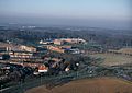
The Louvain-la-Neuve Science Park from above.

See also
 In Spanish: Provincia del Brabante Valón para niños
