
Provinces of Belgium facts for kids
Belgium is a country in Europe that is divided into different parts to help manage it better. It has three main areas called Regions: the Flemish Region, the Walloon Region, and the Brussels-Capital Region. Two of these regions are further split into five smaller areas called provinces. Think of provinces like big counties or states within a region.
Contents
Provinces of the Flemish Region
The Flemish Region is located in the northern part of Belgium. It is mainly Dutch-speaking. Here are its five provinces:
| Province | Antwerp | Limburg | Flemish Brabant | East Flanders | West Flanders |
|---|---|---|---|---|---|
| Names in other languages | Antwerpen (Dutch) Anvers (French) Antwerpen (German) |
Limburg (Dutch) Limbourg (French) Limburg (German) |
Vlaams Brabant (Dutch) Brabant flamand (French) Flämisch-Brabant (German) |
Oost-Vlaanderen (Dutch) Flandre orientale (French) Ostflandern (German) |
West-Vlaanderen (Dutch) Flandre occidentale (French) Westflandern (German) |
| Location | _location.svg) |
_location.svg) |
_location.svg) |
_location.svg) |
_location.svg) |
| Flag |
 |
.svg) |
 |
 |
 |
| Coat of Arms |
 |
_coa.PNG) |
 |
 |
 |
| Area | 2,860 km² (about 1,104 sq mi) | 2,414 km² (about 932 sq mi) | 2,106 km² (about 813 sq mi) | 2,982 km² (about 1,151 sq mi) | 3,151 km² (about 1,217 sq mi) |
| Highest point | Beerzelberg (55 m or 180 ft) | Remersdaal (288 m or 945 ft) | Walshoutem (137 m or 449 ft) | Pottelberg (157 m or 515 ft) | Kemmelberg (156 m or 512 ft) |
| Subdivisions | 3 smaller areas called Arrondissements and 70 towns or cities (municipalities). |
3 Arrondissements and 44 municipalities. |
2 Arrondissements and 65 municipalities. |
6 Arrondissements and 65 municipalities. |
8 Arrondissements and 64 municipalities. |
| Capital City | Antwerp | Hasselt | Leuven | Gent | Brugge |
| Population | 1,682,683 people | 805,786 people | 1,037,786 people | 1,389,199 people | 1,130,040 people |
| Population Density | 587 people per km² | 333 people per km² | 493 people per km² | 459 people per km² | 362 people per km² |
| Governor | Cathy Berx | Steve Stevaert | Lodewijk De Witte | André Denys | Paul Breyne |
A governor is like the main leader or representative of the province. They help manage the province and work with the regional government.
Provinces of the Walloon Region
The Walloon Region is in the southern part of Belgium. Most people here speak French, but there's also a small German-speaking area. Here are its five provinces:
| Province | Hainaut | Walloon Brabant | Namur | Liège | Luxembourg |
|---|---|---|---|---|---|
| Names in other languages | Hainaut (French) Hennegau (German) Henegouwen (Dutch) |
Brabant wallon (French) Wallonisch-Brabant (German) Waals Brabant (Dutch) |
Namur (French) Namur (German) Namen (Dutch) |
Liège (French) Lüttich (German) Luik (Dutch) |
Luxembourg (French) Luxemburg (German) Luxemburg (Dutch) |
| Location | _location.svg) |
_location.svg) |
_location.svg) |
_location.svg) |
_location.svg) |
| Flag |
 |
 |
 |
 |
 |
| Coat of Arms |
 |
 |
 |
 |
 |
| Area | 3,800 km² (about 1,467 sq mi) | 1,093 km² (about 422 sq mi) | 3,664 km² (about 1,415 sq mi) | 3,844 km² (about 1,484 sq mi) | 4,443 km² (about 1,715 sq mi) |
| Subdivisions | 7 Arrondissements and 69 municipalities. |
1 Arrondissement and 27 municipalities. |
3 Arrondissements and 38 municipalities. |
4 Arrondissements and 84 municipalities. |
5 Arrondissements and 44 municipalities. |
| Capital City | Mons | Wavre | Namur | Liège | Arlon |
| Population | 1,309,880 people | 379,515 people | 472,281 people | 1,067,685 people | 269,023 people |
| Population Density | 345 people per km² | 347 people per km² | 129 people per km² | 277 people per km² | 60 people per km² |
| Governor | Claude Durieux | Marie-José Laloy | Denis Mathen | Michel Foret | Bernard Caprasse |
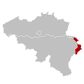
A Possible Third Province: Eupen-Sankt Vith
In Belgium, there's a special area where people speak German. This area is part of the Liège Province in the Walloon Region. Because of their unique language and culture, some people think these 9 German-speaking towns should form their own province. This new province would be called Eupen-Sankt Vith. It would help the German-speaking community have more say in their local government.
Images for kids
-
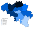
Provinces of Belgium (including the Brussels-Capital Region) by population as of 1 January 2019
-
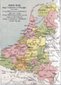
Map of the Seventeen Provinces. The red line shows the border between the independent (Northern) Netherlands and the Southern Netherlands.
-
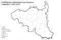
Belgium at its independence in 1830
-
The Brussels Capital Region in Belgium.
-
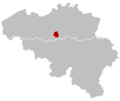
The German-speaking Community.
.png)


See also
 In Spanish: Organización territorial de Bélgica para niños
