
Liège (province) facts for kids
Quick facts for kids Liège |
|||
| Province of Belgium | |||
 The Coo Waterfalls (municipality of Stavelot)
|
|||
|
|||
| Country | |||
|---|---|---|---|
| Region | |||
| Capital | Liège | ||
| - coordinates | 50°39′N 5°34′E / 50.650°N 5.567°E | ||
| Highest point | Signal de Botrange | ||
| - location | Waimes, Verviers, Liège | ||
| - elevation | 694 m (2,277 ft) | ||
| - coordinates | 50°30′06″N 6°05′33″E / 50.50167°N 6.09250°E | ||
| Area | 3,862 km² (1,491 sq mi) | ||
| Population | 1,102,531 (1 January 2017) | ||
| Density | 285 /km² (738 /sq mi) | ||
| Subdivisions | 4 Arrondissements 84 Municipalities |
||
| Governor | Hervé Jamar | ||
| Timezone | CET (UTC+1) | ||
| - summer (DST) | CEST (UTC+2) | ||
| Postal codes | 4000–4999 | ||
| ISO 3166-2 | BE-WLG | ||

.svg)
Liège (Walloon: Lîdje; Dutch: Luik; German: Lüttich) is the province located furthest to the east in the Walloon Region of Belgium. Its main city and capital is Liège.
This area is home to both French and German speaking people. Most residents speak French, but a smaller group speaks German.
Contents
History of Liège Province

The province of Liège as we know it today began as a "department" (a type of administrative area) created by the French government. This happened in the late 1700s and was called the Department of Ourte.
After Napoleon was defeated in 1815, some eastern parts of the department were given to the Prussian empire. These areas included Eupen, Malmedy, Saint-Vith, and four other German towns.
Later, King William I of the Netherlands changed the names of the provinces back to more traditional ones. He named this area Liège, after the old principality of Liège. Even though the new province didn't exactly match the old principality, the name stuck.
After Prussia lost the war in 1919, the areas of Eupen, Malmedy, and Saint-Vith became part of the Liège province again.
Geography of Liège Province
The province of Liège is in southeastern Belgium. It shares borders with the Netherlands, Germany, and Luxembourg. Within Belgium, it borders the provinces of Luxembourg, Namur, Walloon Brabant, Flemish Brabant, and Limburg.
The total area of the province is about 3,862 square kilometers (1,491 square miles). It has a population of over 1 million people. This means there are about 280 people living in each square kilometer.
The highest point in the province, and in all of Belgium, is the Signal de Botrange. It stands at 694 meters (2,277 feet) high. You can find it in Waimes, which is in the Verviers area.
Main Rivers in Liège
The most important river in the province is the Meuse river. It starts in France and flows through Belgium, passing through the provinces of Namur and Liège. After traveling about 950 kilometers (590 miles), it empties into the North Sea.
Other important rivers in the province include:
- Ourthe: This river flows into the Meuse.
- Vesdre: Another river that flows into the Meuse.
- Amblève: This river is a branch of the Ourthe.
- Warche: A smaller river that flows into the Amblève.
- Geer: Another river that joins the Meuse.
How Liège Province is Organized
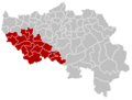
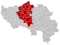
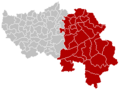
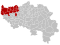
The province of Liège is divided into four main areas called arrondissements. These are:
- Huy
- Liège
- Verviers
- Waremme
Within these four arrondissements, there are a total of 84 smaller towns and villages, known as municipalities. Most of these municipalities (75 of them) are French-speaking, while 9 are German-speaking.

Population Growth in Liège
The population of the province of Liège has been steadily growing. For example, in 2007, the total population was about 1,047,414 people. By 2012, this number had grown to about 1,083,400 people. This shows that more and more people are choosing to live in the Liège province.
Images for kids
-
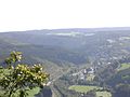
The Coo Waterfalls (municipality of Stavelot)
-
Huy
-
Liège
-
Verviers
-
Waremme


See also
 In Spanish: Provincia de Lieja para niños
