
East Flanders facts for kids
Quick facts for kids East Flanders (Dutch: Oost-VlaanderenFrench: Flandre-Orientale) |
|||
| Province of Belgium | |||
 Historical centre of Ghent
|
|||
|
|||
| Country | |||
|---|---|---|---|
| Region | |||
| Capital | Ghent | ||
| - coordinates | 51°3′N 03°44′E / 51.050°N 3.733°E | ||
| Highest point | Hotondberg | ||
| - location | Kluisbergen, Oudenaarde, East Flanders | ||
| - elevation | 150 m (492 ft) | ||
| Area | 2,991 km² (1,155 sq mi) | ||
| Population | 1,496,187 (1 January 2017) | ||
| Density | 500 /km² (1,295 /sq mi) | ||
| Subdivisions | 6 Arrondissements 65 Municipalities |
||
| Governor | Jan Briers | ||
| Timezone | CET (UTC+1) | ||
| - summer (DST) | CEST (UTC+2) | ||
| Postal codes | 9000–9999 | ||
| ISO 3166-2 | BE-VOV | ||


East Flanders is a province located in Flanders, one of the three main regions of Belgium. Its name in Dutch is Oost-Vlaanderen, and in French it's Flandre-Orientale.
The capital city of East Flanders is Ghent. It is also the largest city in the province.
Contents
What's in a Name?
The name East Flanders tells you that this area is in the eastern part of Flanders. The word Flanders itself has a long history! It first appeared in the year 358 as pagus Flandrensis. Pagus is a Latin word that meant a small town or village with only a few houses.
This pagus Flandrensis region was once a coastal area. It had large channels where tides flowed in and out, and green marshy lands. Sheep farmers lived and worked there.
The modern province of East Flanders was created in 1795. At that time, it was called the Escaut department by the First French Empire. Later, in 1815, when the Kingdom of the Netherlands was formed, this department became the province of East Flanders.
Exploring East Flanders' Geography
East Flanders is located in the western part of Belgium. It shares borders with the Netherlands to the north. Within Belgium, it borders several other provinces. These include Antwerp and Flemish Brabant (both in Flanders), Hainaut (in Wallonia), and West Flanders (also in Flanders).
The province covers an area of about 2,991 square kilometers (1,155 square miles). It is home to over 1.4 million people. This means it's a pretty busy place, with many people living close together.
Ghent is the capital and the biggest city in East Flanders. It's also the second-largest city in the entire Flemish Region. Other important cities in the province include Aalst, Sint-Niklaas, and Dendermonde.
The highest point in East Flanders is a hill called Hotondberg. It stands about 150 meters (492 feet) tall. You can find it in the municipality of Kluisbergen, which is part of the Oudenaarde district.
The main river flowing through the province is the Scheldt (called Schelde in Dutch and Escaut in French). Another important river, the Leie, joins the Scheldt in the city of Ghent. The Dender river also flows into the Scheldt in the city of Dendermonde.
How East Flanders is Organized
East Flanders is divided into smaller areas to help manage it. These areas are called arrondissements. There are six arrondissements in total: Aalst, Dendermonde, Eeklo, Ghent, Oudenaarde, and Sint-Niklaas.
Each arrondissement is then further divided into even smaller local areas called municipalities. In total, East Flanders has 65 municipalities. Each municipality has its own local government that looks after the needs of the people living there.

Images for kids
-
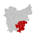
Location of the Aalst Arrondissement
-
Location of the Dendermonde Arrondissement
-
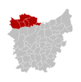
Location of the Eeklo Arrondissement
-
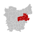
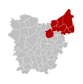
Location of the Ghent Arrondissement
-
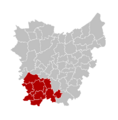
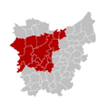
Location of the Oudenaarde Arrondissement
-
Location of the Sint-Niklaas Arrondissement


See also
 In Spanish: Provincia de Flandes Oriental para niños
