
Hainaut (province) facts for kids
Quick facts for kids Hainaut |
|||
| Province of Belgium | |||
.jpg) St. Nicolas of Smyrne church in Enghien
|
|||
|
|||
| Country | |||
|---|---|---|---|
| Region | |||
| Largest city | Charleroi | ||
| Capital | Mons | ||
| - coordinates | 50°27′N 3°57′E / 50.450°N 3.950°E | ||
| Highest point | L'Escaillère | ||
| - location | Chimay, Thuin, Hainaut | ||
| - elevation | 365 m (1,198 ft) | ||
| - coordinates | 49°56′N 04°25′E / 49.933°N 4.417°E | ||
| Area | 3,800 km² (1,467 sq mi) | ||
| Population | 1,339,562 (1 January 2017) | ||
| Density | 353 /km² (914 /sq mi) | ||
| Subdivisions | 7 Arrondissements 69 Municipalities |
||
| Governor | Tommy Leclercq | ||
| Timezone | CET (UTC+1) | ||
| - summer (DST) | CEST (UTC+2) | ||
| Postal codes | 6000–6599/7000–7999 | ||
| ISO 3166-2 | BE-WHT | ||

.svg)
Hainaut (pronounced "Hay-noh") is a province in Belgium. It's part of the Walloon Region, which is one of the three main areas of Belgium. The capital city of Hainaut is Mons.
Hainaut is the westernmost province in the Walloon Region. It's known for its rich history and beautiful landscapes.
Geography
Hainaut shares a border with France to the south. Inside Belgium, it borders several other provinces. These include West Flanders, East Flanders, and Flemish Brabant (which are Flemish provinces). It also borders Walloon Brabant and Namur (which are Walloon provinces).
The province covers an area of about 3,800 square kilometers (1,467 square miles). It has a population of over 1.3 million people. This makes it the most populated province in the Walloon Region.
The land in Hainaut varies in height. The lowest point is about 10 meters (33 feet) above sea level in Celles. The highest point is 365 meters (1,198 feet) high in L'Escaillère.
Administrative Divisions
Hainaut is divided into seven main areas called arrondissements. These are like smaller districts within the province. Each arrondissement has several towns and villages, called municipalities. In total, Hainaut has 69 municipalities.
The seven arrondissements are:
- Ath
- Charleroi
- Mons
- Mouscron
- Soignies
- Thuin
- Tournai

Images for kids
-
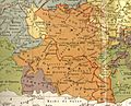
Historical map of the County of Hainaut, with in red the current French-Belgian border.
-
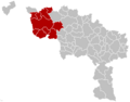
Map of the Ath Arrondissement.
-
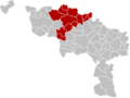
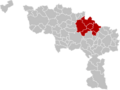
Map of the Charleroi Arrondissement.
-
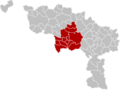
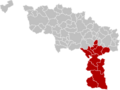
Map of the Mons Arrondissement.
-
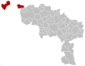
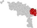
Map of the Mouscron Arrondissement.
-
Map of the Soignies Arrondissement.
-
Map of the Thuin Arrondissement.
-
Map of the Tournai Arrondissement.


See also
 In Spanish: Provincia de Henao para niños
