
Charleroi facts for kids
Quick facts for kids
Charleroi
Tchålerwè (Walloon)
|
|||
|---|---|---|---|
      Clockwise from top: Charleroi's Town Hall; St. Christopher's Church on the Place Charles II; the Place Verte; the Sambre; the Golden House; and the Castle of Monceau-sur-Sambre
|
|||
|
|||

Charleroi
Location in Belgium
|
|||
| Country | Belgium | ||
| Community | French Community | ||
| Region | Wallonia | ||
| Province | Hainaut | ||
| Arrondissement | Charleroi | ||
| Area | |||
| • Total | 102.08 km2 (39.41 sq mi) | ||
| Population
(2018-01-01)Lua error in Module:Wd at line 1575: attempt to index field 'wikibase' (a nil value).
|
|||
| • Total | Lua error in Module:Wd at line 1,575: attempt to index field 'wikibase' (a nil value). | ||
| Postal codes |
6000, 6001, 6010, 6020,
6030–6032, 6040–6044, 6060, 6061 |
||
| Area codes | 071 | ||
| Website | www.charleroi.be | ||
|
|
|||


Charleroi is a city and municipality in Wallonia, Belgium. It is located in the Hainaut province. The city sits in the valley of the Sambre river, in the southwest of Belgium. It is not far from the border with France.
As of January 1, 2008, Charleroi had a population of 201,593 people. Its larger metropolitan area, including nearby towns, had about 522,522 people. This makes it the 5th largest city area in Belgium. People from Charleroi are called Carolorégiens or Carolos.
Contents
History
.jpg)
The Charleroi area has been settled for a very long time. People lived here even in prehistoric times. They had activities like working with metals and trading along the Sambre river. During the Roman period, buildings, temples, and villas were built. Old burial sites with jewelry and weapons have been found too.
The first time a place called Charnoy was written about was in the 9th century. It was mentioned in a document from the Lobbes abbey. This document listed nearby towns and their tithe duties (payments to the church). In the Middle Ages, Charnoy was a small village with only about 50 people. It was part of the County of Namur.
City Foundation
In 1659, Spain lost some land in a treaty. This created a gap between two important fortresses, Mons and Namur. To fill this gap, the Spanish governor, Francisco Castel Rodrigo, decided to build a new fortress. He took land around Charnoy for this purpose.
In September 1666, the new fortress was named Charle-roi, which means "King Charles". This was to honor five-year-old Charles II of Spain. You can find a special message about this in old church records. It says FVNDATVR CAROLOREGIVM (MDCLVVVI).
Building had just started when a war with France began in 1667. The Spanish left, and France took control of the town. The French general Vauban finished the fortifications. A bridge was built over the Sambre river, connecting the upper and lower parts of the town. People were encouraged to move there. France gave up control in 1678. The town changed hands many times over the next 50 years. But it remained part of the Netherlands until modern Belgium was formed.
From 1666 to 1830

After it was founded, Charleroi was attacked by the Dutch. It was given back to the Spanish in 1678. Then the French took it in 1693, and it went back to the Spanish in 1698. Later, the French, Dutch, and Austrians took it in 1714.
The French Prince of Conti took the city again in 1745. But it was given back to Austria in 1748. This started a good time for the city under Joseph II. Industries like glass, steel, and coal, which had started earlier, could now grow.
Problems started again in 1790 with a civil uprising. The Austrians took the city, but the French forced them out in 1792. The Austrians took it back four months later. On June 12, 1794, the French army won a big victory in the Battle of Fleurus. The city was then called Libre-sur-Sambre until 1800. After France lost in 1814, the area became part of the Netherlands. New walls were built around the city. Napoleon stayed in Charleroi for a few days in June 1815, just before the Battle of Waterloo.
From 1830 to Today

The Belgian Revolution in 1830 made the area free from the Netherlands. This led to a new time of growth. This growth was still based on glass, metal, and coal. That's why the area was called Pays Noir ("Black Country"). After the Industrial Revolution, Charleroi grew because more coke was used in making metals. People from all over Europe came for work, and the population grew fast.
From the 1850s, Charleroi became a key place for worker strikes. In 1886, 12 strikers were killed by the army in Roux. Miners from Charleroi also moved to Canada for work. Workers in Charleroi were always important in big Belgian strikes. This included strikes against King Leopold III and the general strike in 1960–1961.
By 1871, the fortified walls around the city were completely removed.
Heavy fighting happened during World War I. This was because of the city's important location on the Sambre. The city was badly damaged. More destruction was stopped by an agreement with the German forces. This agreement required payments and supplies. The magazine Spirou, famous for characters like Lucky Luke and the Smurfs, started in 1938. After World War II, Charleroi's heavy industry began to decline. In 1977, Charleroi merged with several nearby towns. It became the largest city in Wallonia and the 4th largest in Belgium.
City Logo
To improve its image, Charleroi got a new logo in 2015. It was designed by a studio called Pam and Jenny.
The logo has a crown of three triangles above the letter C. This crown has several meanings:
- The triangle shape reminds people of the slag heaps. These were black from coal mining but are now green. They show the city's industrial past.
- It also looks like the rooster symbol of Wallonia.
- The crown refers to King Charles II, who gave his name to the city.
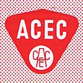
- The letters in the logo are similar to those used by ACEC. This was a big company in Charleroi for over 100 years.
-
Slag heap
-
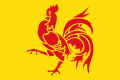
Flag of Wallonia
-
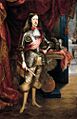
King Charles II
-
Typography
.JPG)


Geography

The city of Charleroi is on both sides of the Sambre river. This area was known for its industrial activities, like coal mining and steel industry. It was nicknamed the Pays Noir ("Black Country"). Even though most factories have closed, you can still see spoil tips (piles of waste from mining) and old industrial buildings.
Charleroi is about 50 kilometers (31 miles) south of Brussels.
The municipality of Charleroi includes:
- I. The main central district of Charleroi
And these former towns, which became part of Charleroi in 1977:
- II. Dampremy
- III. Lodelinsart
- IV. Gilly
- V. Montignies-sur-Sambre
- VI. Couillet
- VII. Marcinelle
- VIII. Mont-sur-Marchienne
- IX. Marchienne-au-Pont
- X. Monceau-sur-Sambre
- XI. Goutroux
- XII. Roux
- XIII. Jumet
- XIV. Gosselies
- XV. Ransart
Neighboring towns:
- a. Les Bons Villers
- b. Fleurus
- c. Châtelet
- d. Gerpinnes
- e. Ham-sur-Heure-Nalinnes
- f. Montigny-le-Tilleul
- g. Fontaine-l'Évêque
- h. Courcelles
- i. Pont-à-Celles
Rivers and Hills

Charleroi's landscape is shaped by the Sambre river valley. The Sambre flows from west to east and joins the Meuse river in Namur. The Piéton river flows south to join the Sambre. The Charleroi-Brussels canal is built in this valley. The Eau d'Heure river also flows into the Sambre. About twenty smaller streams run through the area.
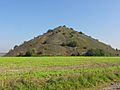
The land ranges from 100 meters (328 feet) in the river valleys to over 220 meters (722 feet) at the Bois du Prince. The main square, Place Charles II, is 132 meters (433 feet) high. The slag heaps are often over 200 meters (656 feet) tall. The Saint-Charles slag heap at the Bois du Cazier is 241 meters (791 feet) high.
Nature and Wildlife
The six slag heaps in the Pays Noir are important for biodiversity. They are home to many special and often rare animals and plants. These species depend on these unique environments.
For example, the Viviers site in Gilly is an old mining area. It has a small slag heap and open grassy areas. It also has a small pond and some wooded parts. This special place is a refuge for many different animals. The reed bed around the pond is home to the red warbler, a bird that likes this type of plant. You can also see different amphibians here, like the natterjack toad. Some insects, like the beautiful blue-winged grasshopper, also live here.
The Martinet site, another former coal mine, is being restored. Like Viviers, this large site is very important for nature.
Climate
Charleroi has an oceanic climate, like the rest of Belgium. This means winters are milder and summers are not too hot. This is because of the Gulf Stream from the ocean.
| Climate data for Charleroi (1991–2020 normals) | |||||||||||||
|---|---|---|---|---|---|---|---|---|---|---|---|---|---|
| Month | Jan | Feb | Mar | Apr | May | Jun | Jul | Aug | Sep | Oct | Nov | Dec | Year |
| Record high °C (°F) | 15.2 (59.4) |
19.5 (67.1) |
23.9 (75.0) |
28.7 (83.7) |
31.8 (89.2) |
34.4 (93.9) |
40.4 (104.7) |
36.6 (97.9) |
35.4 (95.7) |
26.0 (78.8) |
20.4 (68.7) |
16.7 (62.1) |
40.4 (104.7) |
| Mean daily maximum °C (°F) | 5.8 (42.4) |
6.9 (44.4) |
10.7 (51.3) |
14.8 (58.6) |
18.4 (65.1) |
21.4 (70.5) |
23.6 (74.5) |
23.4 (74.1) |
19.6 (67.3) |
14.8 (58.6) |
9.6 (49.3) |
6.3 (43.3) |
14.6 (58.3) |
| Daily mean °C (°F) | 3.2 (37.8) |
3.7 (38.7) |
6.5 (43.7) |
9.7 (49.5) |
13.4 (56.1) |
16.4 (61.5) |
18.5 (65.3) |
18.2 (64.8) |
14.9 (58.8) |
11.0 (51.8) |
6.8 (44.2) |
3.8 (38.8) |
10.5 (50.9) |
| Mean daily minimum °C (°F) | 0.6 (33.1) |
0.6 (33.1) |
2.4 (36.3) |
4.7 (40.5) |
8.4 (47.1) |
11.3 (52.3) |
13.4 (56.1) |
13.1 (55.6) |
10.1 (50.2) |
7.2 (45.0) |
3.9 (39.0) |
1.4 (34.5) |
6.4 (43.6) |
| Record low °C (°F) | −17.5 (0.5) |
−16.7 (1.9) |
−10.1 (13.8) |
−5.5 (22.1) |
0.1 (32.2) |
3.7 (38.7) |
5.6 (42.1) |
6.0 (42.8) |
2.9 (37.2) |
−5.3 (22.5) |
−8.7 (16.3) |
−11.8 (10.8) |
−17.5 (0.5) |
| Average precipitation mm (inches) | 79.7 (3.14) |
69.9 (2.75) |
65.5 (2.58) |
47.9 (1.89) |
65.1 (2.56) |
76.0 (2.99) |
75.6 (2.98) |
85.6 (3.37) |
63.3 (2.49) |
67.1 (2.64) |
75.7 (2.98) |
98.3 (3.87) |
869.7 (34.24) |
| Average precipitation days (≥ 1 mm) | 12.8 | 11.6 | 11.3 | 9.1 | 10.2 | 10.2 | 10.2 | 10.3 | 9.6 | 10.6 | 12.1 | 14.4 | 132.4 |
| Mean monthly sunshine hours | 55 | 73 | 126 | 178 | 204 | 208 | 217 | 206 | 157 | 114 | 64 | 47 | 1,649 |
| Source 1: Royal Meteorological Institute | |||||||||||||
| Source 2: Infoclimat | |||||||||||||
Landmarks


- The belfry, which is part of the City Hall, is a UNESCO World Heritage List site. It was added in 1999.
- The Maison Dorée (Golden House) was built in 1899. It was designed by Alfred Frère, an Art Nouveau architect. It's called "Golden House" because of the golden decorations on its outside walls.
- Charleroi has several museums. These include museums of fine art, glass, and a large photography museum in the Mont-sur-Marchienne area.
- The Castle of Monceau-sur-Sambre is in a big English-style park. It's a tall building with round towers, mostly from the 17th and 18th centuries.
- Saint-Christophe Church (Charleroi Ville-Haute) started being built in 1667. It has been restored and changed to a modern style in 1956.
- The Protestant Church of Belgium (Charleroi Ville-Haute) has held English-speaking services since 1933.
- The former Post Office building (Charleroi Ville-Basse) has a belfry. It was built in 1907 in a Flemish neo-renaissance style.
- Nine special stones called Stolpersteine in Charleroi have been placed in Charleroi. They remember Jewish people who were killed during the Nazi regime.
- The Bois du Cazier in Marcinelle is an old coal mining site. It was added to the UNESCO World Heritage List in 2012. It has a museum about industry and glass.
- The Tour Bleue ("Blue Tower") is 75 meters (246 feet) high. It was built in 2015 and is the police headquarters.
Economy
Charleroi used to be a major center for coal mining, steel, and glass industries. However, these industries declined a lot from the 1970s to the 1990s.
Despite this, the Charleroi region still has a large industrial area. It is used for electrical engineering and making iron, steel, glass, and chemicals. For example, the company ArcelorMittal has a steelworks here.
Since the early 2000s, the economy has become more diverse. It now includes healthcare, logistics, biotechnology, energy (Suez), railway transport (Alstom), and telecommunications (Alcatel).
More recently, other areas have grown. These include civil and military aviation (SABCA, SONACA), logistics, printing, and biotechnology. The aviation industry is growing fast around the Charleroi-Brussels-South airport. Two university research centers are there: CETIC and Cenaero.
The Brussels South Charleroi Airport has become very successful. The number of passengers grew from 210,000 in 1998 to 8.3 million in 2023. It is now Belgium's second-busiest airport for passengers. This helps the region's economy and creates many jobs.
Igretec is an official group that helps new high-tech companies. They support businesses setting up near the airport and in the Charleroi region.
Charleroi is also connected by highways to all major Belgian cities and the French border. It has a port ("Port autonome de Charleroi") and a river system. This allows goods to reach three big ports: Dunkirk, Antwerp, and Rotterdam.
Since the 1990s, two large shopping malls (Ville 2 and Rive Gauche) have been built. Cinemas and a local craft brewery have also opened. These have brought more shops and customers back to the city center.
Education
Charleroi is Belgium's biggest city without its own main university. However, several universities have campuses here. In 1966, the University of Louvain started operations in Charleroi. It has faculties for management and engineering. Other universities like Namur, Mons, and the Université libre de Bruxelles also have programs.
A new Campus of Sciences, Art and Trade is being built downtown. This project is supported by the European Regional Development Fund (ERDF). It will be a center for training, teaching, and research. It will include a Cité des Métiers (City of Trades) and university centers.
Primary and Secondary Schools

Some of the secondary schools in Charleroi are:
- Athénée Royal Jules Destrée
- Athénée Royal Orsini Dewerpe
- Athénée Royal de Gilly
- Athénée Royal Les Marlaires
- Athénée Royal Ernest Solvay
- Athénée Royal Vauban
- Athénée Royal Yvonne Vieslet
- Centre Educatif Communal Secondaire — La Garenne
- Institut d'Enseignement Technique Secondaire de l’UT
- Institut Jean Jaurès de l’UT
- Centre Educatif Communal Secondaire de Couillet-Marcinelle
- Institut Provincial d’Enseignement Secondaire Paramédical La Samaritaine
Catholic secondary schools include:
- Institut Saint-Joseph (ISJ)
- Institut Saint-André (ISA)
- Institut Notre-Dame (IND)
- IET Notre-Dame (IETND)
- Collège du Sacré-Cœur (Jesuits)
- Collège Technique Aumôniers du Travail de Charleroi (ATC)
Transport

Air Travel
The Brussels South Charleroi Airport is in Gosselies, 7 kilometers (4.3 miles) north of the city center. It opened in 1919 as a flight school. Later, it housed the Fairey aircraft factory.
Today, Gosselies is used as an alternative airport for Brussels. Low-cost airlines like Ryanair and Wizz Air use it a lot. Seasonal holiday flights also use this airport.
A new terminal opened in January 2008. It replaced an older, smaller building that was too crowded.
Brussels is 47 kilometers (29 miles) north of Charleroi Airport. In October 2021, the runway was made 650 meters (2,133 feet) longer. It is now 3,200 meters (10,500 feet) long.
Train Travel
Charleroi is connected by train to other big Belgian cities. The main station is Charleroi-Central railway station. The city also has a smaller station, Charleroi-West. This station is on the line to Ottignies.
River Transport
The Port autonome de Charleroi allows access to a network of canals and rivers. This connects Charleroi to three major ports: Dunkirk, Antwerp, and Rotterdam. It has 29 ports in the Charleroi region. These are along the river Sambre and the Brussels-Charleroi canal. The port has 8 kilometers (5 miles) of riverbanks. About 5 million tons of goods are transported each year. It also handles 10,000 containers. Over 100 companies use the port, creating 1,700 direct and 1,000 indirect jobs.
Public Transport


Public transport is run by TEC. This is the Walloon public transport service. The Charleroi area has bus lines and a light-rail Metro system. This system is called the Métro Léger de Charleroi. Part of it uses old tracks from the Vicinal tramway, which was Belgium's old national tram network.
Charleroi also has a planned suburban rail system called the Réseau express régional de Charleroi (Réseau S).
Charleroi Metro
The Charleroi Metro is known for parts that were never finished. It was planned in the 1960s to be a 48-kilometer (30-mile) network. It would have eight lines going out from a central loop downtown. However, only one line, part of another, and three-quarters of the loop were built and opened. This happened between 1976 and 1996.
Another line towards Châtelet was almost fully built. It even had power cables and escalators. But it was never opened because not enough people would use it. High building costs and a decline in Charleroi's industries were reasons the original plan wasn't completed.
The central loop and the Gilly line were finished in 2012. The Gosselies line opened as a street-level tram in 2013. In June 2021, it was announced that €60 million will be used to fix and open the Châtelet "ghost" line. It will also be extended to a new hospital.
In June 2021, the first renovated tram was shown. This €22 million project will update the entire tram fleet by 2026.
Demographics
| Group of origin | Year | |
|---|---|---|
| 2023 | ||
| Number | % | |
| Belgians with Belgian background | 98,798 | 48.48% |
| Belgians with foreign background | 70,839 | 34.76% |
| Neighboring country | 5,991 | 2.94% |
| EU27 (excluding neighbouring country) | 26,518 | 13.01% |
| Outside EU 27 | 38,330 | 18.81% |
| Non-Belgians | 32,367 | 15.88% |
| Neighbouring country | 2,529 | 1.24% |
| EU27 (excluding neighbouring country) | 15,152 | 7.44% |
| Outside EU 27 | 14,686 | 7.21% |
| Total | 203,785 | 100% |
Culture


Museums
- Musée de la photographie (Photography Museum), in Mont-sur-Marchienne
- BPS22, art Museum of the Province of Hainaut
- Bois du Cazier, in Marcinelle
- Musée des Beaux-Arts ("Museum of Fine Arts")
Theatres and Dance Halls
- Charleroi Danses
- Théâtre de l'Ancre
Performance Halls and Cultural Centers
- Rockerill, an alternative concert hall and exhibition space in Marchienne-au-Pont
- Vecteur, a cultural platform for different arts
- Eden, a performance hall
Media
- Éditions Dupuis, a publisher of comics and magazines in Marcinelle
- Telesambre, a regional television channel
- La Nouvelle Gazette, a Belgian French-language daily newspaper
Local Events
- The Marches of Entre-Sambre-et-Meuse: These are religious processions and folk marches. They happen every year from May to October. Many people parade in old military costumes. In 2012, fifteen of these marches were recognized by UNESCO.
- The Mardi Gras carnival: This event features giant puppets and a parade by the Climbias, a local club.
- The Easter and August fairs.
- The Sunday market.
Walking and Cycling Routes
- Boucle Noire ("Black Loop"): A 26-kilometer (16-mile) walk. It takes you through Charleroi's industrial and natural areas.
- Grande dérive ("Big Drift"): This path is a 54-kilometer (34-mile) loop around Charleroi. It goes through green areas, slag heaps, parks, woods, and farmlands.
- Eurovelo 3 pilgrims' route: Charleroi is on this long cycling route. It is 5,122 kilometers (3,183 miles) long and connects Trondheim in Norway to Santiago de Compostela in Spain. It crosses seven countries.
- The RAVeL network: This is a network of safe paths for cycling and tourism. The routes follow old towpaths along the Sambre river and the Charleroi-Brussels canal. They also use old railway lines.
Sports

Charleroi is home to several successful sports teams.
- Spirou Charleroi is a basketball team that has won the Belgian League eight times.
- La Villette Charleroi is a table tennis club. It has won the Champions League five times and many Belgian titles.
- Action 21 Charleroi is a futsal (indoor soccer) team. It has won one UEFA Futsal Cup and nine Belgian titles.
- In football (soccer), Royal Charleroi SC and ROC Charleroi have both finished second in the Belgian Pro League.
- The Stade du Pays de Charleroi is a football stadium with 30,000 seats. It was used for UEFA Euro 2000.
Notable People from Charleroi

Born in Charleroi
- Léon Rosenfeld (1904–1974), physicist
- Jean-Marie André, scientist
- Alexandre Czerniatynski, football player
- Jules Delhaize, founder of what became the Delhaize Group
- Louis Delhaize, founder of the Louis Delhaize Group
- Jules Destrée, lawyer and politician
- Karl Erjavec, Slovenian lawyer and politician
- Paul Finet (1897–1965), Belgian politician
- Albert Frère, businessman
- Régis Genaux, football player
- Emile Grumieaux, painter
- Paul-François Huart-Chapel, industrialist
- Jean-Pierre Lecocq (1947–1992), molecular biologist
- Georges Lemaître (1894–1966), priest and astronomer
- Fabrice Lig, music producer
- Loïc Nottet, musician
- Jean Dupuis, printer and editor
- Pierre Marcolini, chocolatier
- Joseph Maréchal, Jesuit priest and philosopher
- Didier Matrige, painter and draughtsman
- Joëlle Milquet, politician
- Chantal Mouffe, political theorist
- François-Joseph Navez, painter
- Paul Pastur, lawyer and politician
- Gaston Salmon (1878–1917), Olympic fencer
- Marcel Thiry, poet
- Jeanne Toussaint (1887–1976), jeweller
- Raymond Troye, wartime writer
- Annette Vande Gorne, composer
- Fernand Verhaegen, painter and etcher
Lived in Charleroi
- Robert Arcq, writer
- Paul Cuvelier, painter and comics artist
- Arthur Grumiaux, violinist
- Ernest Solvay, Belgian chemist and industrialist
- Paul Magnette, Belgian politician and current mayor of Charleroi
- René Magritte, painter
- Pierre Paulus, Expressionist painter
- Johan Nunez, drummer
- Arthur Rimbaud, poet
- Paul Verlaine, poet
Twin Cities
Charleroi is twinned with these cities:
See also
 In Spanish: Charleroi para niños
