
Sélestat facts for kids
Quick facts for kids
Sélestat
|
||
|---|---|---|
|
Subprefecture and commune
|
||

The Clock Tower
|
||
|
||

Sélestat
Location in France

Sélestat
Location in Grand Est
|
||
| Country | France | |
| Region | Grand Est | |
| Department | Bas-Rhin | |
| Arrondissement | Sélestat-Erstein | |
| Canton | Sélestat | |
| Intercommunality | CC de Sélestat | |
| Area
1
|
44.40 km2 (17.14 sq mi) | |
| Population
(2021)
|
19,300 | |
| • Density | 434.7/km2 (1,125.8/sq mi) | |
| Time zone | UTC+01:00 (CET) | |
| • Summer (DST) | UTC+02:00 (CEST) | |
| INSEE/Postal code |
67462 /67600
|
|
| Elevation | 165–184 m (541–604 ft) (avg. 173 m or 568 ft) |
|
| 1 French Land Register data, which excludes lakes, ponds, glaciers > 1 km2 (0.386 sq mi or 247 acres) and river estuaries. | ||
.svg)
Sélestat is a town in the Grand Est region of France. It's known as Schlettstàdt in Alsatian and Schlettstadt in German. Sélestat is an important administrative center (a subprefecture) in the Bas-Rhin area. The town sits by the Ill river, about 17 kilometers (10.5 miles) from the Rhine river and the German border. It is located between two of the biggest towns in Alsace: Strasbourg and Mulhouse.
In 2019, Sélestat had about 19,242 people living there, making it the eighth largest town in Alsace. Long ago, during the Middle Ages and the Renaissance, it was the third biggest city in the region, after Strasbourg and Colmar. Today, it's still ranked third in Alsace for its amazing cultural history. Sélestat started as a port on the Ill river in the 8th century. It became rich and important because of wine trade and a lively religious and cultural scene. But its importance slowly faded after the Protestant Reformation and when France took control in the 1600s. The town began to grow again in the second half of the 20th century, becoming a small hub for industry and culture.
Sélestat has a rich history, including the famous Humanist Library of Sélestat and two impressive medieval churches. This makes it a popular place for tourists in Alsace. It's also located on the Alsace wine road and is close to the Haut-Kœnigsbourg castle. Besides its old medieval town, Sélestat also has a nature reserve with one of France's largest riparian forests (forests along a river).
Contents
Town Name

The name "Sélestat" is the French version of its original Germanic name. This French name appeared after France took over in the 17th century. In Alsatian, the town is called Schlettstàdt, and in German, it's Schlettstadt.
Sélestat was first written down as Sclastat in 727. Over time, its name changed in records to Scalistati (775), Slectistat (881), Sclezistat (884), and Slezestat (1095). The German name, Schlettstadt, showed up in 1310. From the 17th to the 19th century, French leaders used different spellings like Sélestat and Schlestadt. Between 1871 and 1919, when Alsace was part of the German Empire, the town was officially called Schlettstadt. Since 1920, the French name Sélestat has been the official one.
No one is completely sure where the name "Schlettstadt" comes from. It probably comes from old Germanic words like slade or sclade, meaning "marshes," and stat, meaning "city." So, Sélestat might mean "city in the marshes." This makes sense because it's in the Grand Ried, a large area in Alsace that often floods. Stat could also mean "area" instead of "city."
There's a fun story that says the town got its name from a dragon named Schletto. This dragon supposedly founded the town after opening up the nearby Lièpvre valley in the Vosges mountains.
History of Sélestat
How the Town Began

Sélestat was first mentioned in 727 AD, but it might have been settled even earlier by Celts or Romans. Digs have found signs of people living here during the Mesolithic, Neolithic, and Bronze Age periods. Many wooden poles from the 1st and 2nd centuries AD were found near St. Quirin chapel. This suggests a Roman settlement. Back then, Sélestat might have already been a port on the Ill river.
When Sélestat first appeared in written records in the 8th century, it was likely a market town or a village of fishermen and farmers. The area belonged to Eberhard, an Alsatian duke, who gave it to Murbach Abbey. In 775, Charlemagne spent Christmas in Sélestat. This shows the town was big enough to host his court and soldiers.
In the 1080s, Sélestat was owned by Hildegard von Eguisheim, mother of Frederick I, Duke of Swabia. She made Sélestat a religious center by founding St. Faith's Church. She gave it to the Benedictines from Conques Abbey. Monks from Conques opened a priory (a small monastery) next to the church in 1092. The House of Hohenstaufen family soon became very powerful in the Holy Roman Empire. Because Sélestat was under their protection, the priory had a big influence on local life. Even though Sélestat had its own church, the Benedictine prior was the real leader of the town. By the late 12th century, the Hohenstaufen family lost power, and the priory started to decline. The people of Sélestat used this chance to gain more control. They began building a new church, St. George's Church, in the 1220s. This church was built in the Gothic style and was much bigger than St. Faith's. This showed that the Benedictines were no longer in charge.
A Free Imperial City
.jpg)
Frederick II, who ruled the Holy Roman Empire in the 1200s, saw his family losing power. To keep cities loyal, he gave them more freedom. These cities became Free imperial cities, and Sélestat became one in 1217. With this new status, Sélestat could build its own city walls and collect its own taxes. Its serfs (people tied to the land) and new settlers became free. In 1292, the German king Adolf of Nassau gave Sélestat a special set of rules, like a constitution. These rules were changed many times but guided local politics until 1789.
Being a free city helped Sélestat with trade and made it rich. But free cities in Alsace worried they wouldn't be protected by the Empire if there was a war. So, in 1354, they formed an alliance called the Decapolis. This group had ten cities: Haguenau, Colmar, Wissembourg, Turckheim, Obernai, Kaysersberg, Rosheim, Munster, Sélestat, and Mulhouse. The main office was in Haguenau, but Sélestat kept the alliance's important papers. Because Sélestat was in the middle of the region, it often hosted meetings for the group.
The Benedictine priory closed in 1424 after many years of losing power. Local nobles had taken over, and then wealthy citizens (the bourgeoisie) took their place in the mid-1300s. Still, Sélestat remained a religious center. New convents were built in the 13th century by Dominicans, Knights Hospitaller, and Franciscans. Some abbeys outside town also had places to stay in Sélestat. By the early 1500s, Sélestat was famous for Renaissance humanism because of its excellent Latin school. Famous reformers like Beatus Rhenanus and Martin Bucer went to this school. The school helped spread Protestant ideas, even though local leaders stayed loyal to the Catholic Church. Erasmus of Rotterdam visited Sélestat four times between 1515 and 1522.
As a free city, Sélestat attracted people looking for safety, freedom, and good business. The first city wall became too small, so a new one was built in 1280. A third wall was needed in the 16th century as the city grew. By the end of the Middle Ages, Sélestat had about 5,000 to 6,000 people. It was the fourth largest Alsatian town. The local economy was strongest around 1500. It focused on shipping and trading goods like hay, grains, wine, fish, glass, iron, and salt. Since roads were bad and dangerous, goods traveled mainly by the Ill river.
Decline of the Town

The town started to decline in the 1520s when the humanist school lost its influence. The problems around the Protestant Reformation brought trouble to the region. Sélestat faced the German Peasants' War in 1525, and its convents were attacked by a crowd in 1534. Around the same time, Sélestat lost its leading role in the Decapolis. This happened because Mulhouse left the alliance in 1515 and was replaced by Landau in 1521, shifting the alliance's center north.
During the 17th century, Alsace was a major battlefield in the Thirty Years War. Sélestat was taken by the Swedes in 1632 after a month-long siege. They gave the town to their French allies two years later. Most local people remained loyal to the House of Habsburg for a long time. The Peace of Westphalia (1648) officially made the Decapolis part of France. Sélestat was briefly taken by the Germans during the Franco-Dutch War in 1674. The Treaties of Nijmegen (1679) ended that war and also ended the Decapolis alliance.
At first, Sélestat was a very important military base for the French. It was near the Rhine river and controlled access to the Vosges mountains and the rest of France. Vauban, a famous military architect, rebuilt the town walls between 1675 and 1691. However, after Strasbourg was taken in 1681, Sélestat became less important because Strasbourg was in a better location. But Sélestat remained a town with soldiers, and their presence helped the struggling local economy. Even though Protestantism was allowed in Alsace, French leaders strongly supported Catholicism. They opened three new convents in Sélestat. Jewish people were forced to leave the town in 1642. During the French Revolution, the people of Sélestat were very traditional and didn't like changes. The new way of organizing areas showed the town's decline. It didn't become a main administrative center (a prefecture). It only became a subprefecture in 1806, replacing Barr. Sélestat suffered during the Napoleonic wars. It was attacked and bombed by the Bavarians in 1814 and blocked by a German group in 1815.
Sélestat Since 1815

Industry started early in Sélestat. By the early 1800s, the town already had several factories: a tile factory, a sawmill, 12 tanneries (for leather), and 11 mills. Sélestat became known for making wire gauze. However, it never grew into a large industrial hub, staying a small town with limited influence. The opening of the Strasbourg-Basel railway in 1840, one of France's first, didn't lead to much city growth. The town walls, which still surrounded the town, greatly held back its economic and population growth.
After the Franco-Prussian War of 1870, Alsace and part of Lorraine became part of the new German Empire. The German authorities tore down the city walls in 1874. They then built new, spacious neighborhoods around the old town, just like they did in Strasbourg and Metz.
Sélestat became French again after the First World War, where nearly a thousand residents died. After the Battle of France in the Second World War, Nazi Germany took over Sélestat. It took three months to free the town, finally happening in February 1945. Sélestat has received the Croix de guerre (War Cross) awards from both 1914–1918 and 1939–1945. Since 1945, Sélestat has seen steady growth in its population and economy. Its population almost doubled between 1946 and 1999. Two industrial parks were built for new large factories. Since the 1970s, the service industry, with many small businesses, has also boosted the town's economy.
South of the town, a large broadcasting facility was used for radio signals. It opened in 1948 and stopped broadcasting on January 1, 2016.
How Sélestat is Governed

Sélestat is one of six subprefectures in the Bas-Rhin area. This means it is the main town for the Sélestat-Erstein arrondissement (a type of administrative district). Sélestat is also the center of a canton, which includes 28 other towns. This canton is mainly used for local elections. For national elections, Sélestat is part of the 5th Bas-Rhin area. Since 2002, Antoine Herth from The Republicans party has been the Member of the National Assembly for this area.
Sélestat is part of a group of towns called the Communauté de communes de Sélestat. This group shares responsibilities and includes Sélestat and 11 nearby villages. It was created in 1995, replacing a similar group from 1969. Sélestat is also the main town of Central Alsace's pays, a group working to develop the area.
The town has had a council since 1292, when it got its own rules under the Holy Roman Empire. These rules shaped local politics until the French Revolution in 1789. Since then, Sélestat has been run like all other towns in France. Its council currently has 33 members. The number of council members depends on the town's population. The town also has a mayor, who is chosen by the council members.
Alsace generally supports right-wing politics in France. The main French right-wing party, The Republicans, currently holds most seats on the council (26 members). Marcel Bauer, who has been mayor since 2001, is also a member of this party. Voters in Sélestat usually vote for right-wing candidates in other elections too. However, Sélestat was governed by the Socialist Party between 1989 and 2001.
Geography of Sélestat

Sélestat is right in the middle of Alsace. It's near the border between the Bas-Rhin and Haut-Rhin areas, which used to be called Lower and Upper Alsace. The town is located between Strasbourg (42 km or 26 miles north) and Mulhouse (57 km or 35 miles south). Sélestat is also between Obernai (22 km or 14 miles) and Colmar (21 km or 13 miles). On the other side of the Rhine river, Freiburg im Breisgau in Germany is about 40 km (25 miles) away.
Sélestat sits on the Alsace plains, a fertile area between the Rhine river and the Vosges mountains. The Ill river flows through Sélestat, running parallel to the Rhine. This river often splits into smaller streams and swells, making the area very wet and prone to flooding. Sélestat is only 4 km (2.5 miles) from the Vosges mountains. It's at the opening of one of the few valleys that cross the mountains, connecting to the rest of France. This valley follows the Giessen river, a 35 km (22 miles) long river that flows into the Ill. Unlike the Ill, which has a steady flow, the Giessen is a mountain river. Its water level can rise suddenly, especially when snow melts in spring. The Giessen flows north of the town and joins the Ill several kilometers to the east, near Ebersmunster.
The town itself is built on the Giessen's alluvial fan (a fan-shaped deposit of sediment), so it's a bit higher than the rest of the Alsace plains. However, much of its land is still in areas that can flood. These areas are mostly inside the Illwald natural reserve and include both forests and meadows. In this reserve, the Ill river forms over 150 km (93 miles) of waterways.
-
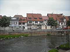
The Ill in Sélestat.
-
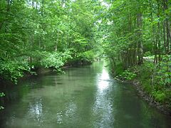
The Oberriedgraben in the Illwald.
-
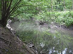
The Schiffwasser in the Illwald.
-
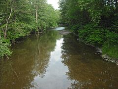
The Giessen.


Transport in Sélestat


Even though Sélestat is a small town, it has good connections to transport networks. Alsace, where Sélestat is located, is part of Europe's economic heart. This means it has many roads and railways.
The town is served by the A35 autoroute, a major highway that runs north to south through Alsace. It connects Strasbourg, Colmar, and Mulhouse. Further south, it links to the Swiss A3 motorway. To the north, it connects to the German B9 highway. Together, these roads connect the Netherlands to Austria. Sélestat is also at one of the seven places where you can cross the Vosges mountains. This connects Lorraine to Alsace and Germany.
Sélestat train station opened in 1840, making it one of the oldest in France. It's on the Strasbourg–Basel railway, which also serves Colmar, Mulhouse, and Saint-Louis. Sélestat is the end point for two local railways that are partly closed. One goes towards the west through the Vosges mountains, ending in Lièpvre. The other goes northwest, ending in Molsheim. A third local line, Sélestat-Sundhouse, closed in 1953. Even though it's old, the Strasbourg-Basel railway allows fast travel (200 km/h or 124 mph). This is because it's very straight and crosses flat land. Sélestat has regional trains between Strasbourg and Basel every hour on weekdays. Local trains also run between Sélestat and Molsheim, Sélestat and Strasbourg, and Sélestat and Barr. Sélestat is also served by a Paris-Colmar TGV (high-speed train) daily. In summer, Intercités trains connect Strasbourg to Nice and Strasbourg to Cerbère. EuroCity trains connect Zürich to Brussels and Basel to Luxembourg.
The SNCF (French national railway company) and the Bas-Rhin council run bus lines between Sélestat and towns like Sainte-Marie-aux-Mines, Saint-Dié-des-Vosges, Ribeauvillé, Marckolsheim, Sundhouse, and Villé. The council also arranges special buses during certain seasons to Haut-Kœnigsbourg castle and Europa Park.
Sélestat and its group of towns have their own local bus network called "Transport intercommunal de Sélestat" (TIS). It has two lines. One connects Châtenois to Ebersheim. The other connects Scherwiller to Muttersholtz. These two lines have several stops in Sélestat itself, which is the center of the bus network.
Population of Sélestat
| Historical population | |||||||||||||||||||||||||||||||||||||||||||||||||||||||||||||||||||||||||||||||||||||||||||||||||||||||||||||||||||||||
|---|---|---|---|---|---|---|---|---|---|---|---|---|---|---|---|---|---|---|---|---|---|---|---|---|---|---|---|---|---|---|---|---|---|---|---|---|---|---|---|---|---|---|---|---|---|---|---|---|---|---|---|---|---|---|---|---|---|---|---|---|---|---|---|---|---|---|---|---|---|---|---|---|---|---|---|---|---|---|---|---|---|---|---|---|---|---|---|---|---|---|---|---|---|---|---|---|---|---|---|---|---|---|---|---|---|---|---|---|---|---|---|---|---|---|---|---|---|---|---|
|
|
|
|||||||||||||||||||||||||||||||||||||||||||||||||||||||||||||||||||||||||||||||||||||||||||||||||||||||||||||||||||||
| Sources: Base Cassini from EHESS for figures until 1962, and INSEE for figures since 1968 | |||||||||||||||||||||||||||||||||||||||||||||||||||||||||||||||||||||||||||||||||||||||||||||||||||||||||||||||||||||||
As of 2019, Sélestat had 19,242 people living there. It is the 8th most populated town in Alsace. Its population reached its highest point in 2006, with 19,459 residents. The oldest birth records for the town's Catholic church go back to 1608. The oldest official records of births, deaths, and marriages go back to 1793.
Sélestat was one of the biggest towns in the region from the Middle Ages until the early 1800s. In 1801, it was still the third most populated town in Alsace, after Strasbourg and Colmar. It had 7,375 people, which was slightly more than Mulhouse (7,197) and Haguenau (7,009). Throughout the 19th century, Sélestat didn't benefit much from industrial growth or people moving from farms to cities. This was because its city wall and military role stopped the town from growing. Around 1830, it had too many people for its small area (about 10,000 people living on only 32 hectares or 79 acres).
Only after the Second World War did Sélestat's population grow a lot, almost doubling in 50 years. However, this growth wasn't enough for Sélestat to regain its earlier high rank among towns.
The population growth in Sélestat after 1945 was mainly due to a high birth rate. Between 1968 and 1975, the birth rate in Sélestat was 20.1 births per 1,000 people, compared to 16.9 per 1,000 in France overall. After 1975, this rate slowly dropped to match the national average. The number of people moving into Sélestat was slightly lower than those moving out until 1990. This was because Sélestat and Central Alsace were on the edge of the bigger cities of Strasbourg and Colmar and weren't as appealing. Since 1990, the Strasbourg area has grown and reached Sélestat. This has made the town more attractive to new residents.
Sélestat's population is relatively young. In 2017, 36.2% of the people were under 30 (compared to 35.7% for all of France). The percentage of people over 60 years old (23.6%) was lower than the national average (25.5%). Sélestat has many people between 15 and 44 years old (39.7%, compared to 36.4% for France). This is because it attracts many young working people and couples starting families. Like other towns in the region, such as Saverne, Haguenau, and Molsheim, Sélestat welcomes young adults and encourages them to settle in the nearby villages.
Economy of Sélestat

At the end of 2015, Sélestat had 2,142 businesses. Most of them (1,441) were in the service industry. Many were small businesses; only 9% had more than 10 employees. Sélestat is a center for shopping and services for all of Central Alsace. It has a large shopping area and many government and educational buildings. However, there are still some large factories, such as Société alsacienne de meubles (which makes kitchens and bathrooms), Amcor (aluminum packaging), Daramic (battery parts), Albany (gauzes for printing), Wanzl (warehouse equipment), and DHJ (textiles).
Most of the big factories are in an industrial area south of the town center. This area was created in the 1930s and covers 67 hectares (166 acres). A newer shopping area north of town was developed in the 1970s. It is for retail stores and small businesses. This area covers 134 hectares (331 acres). The town center is also an important shopping district with over 200 businesses.
Sights and Culture
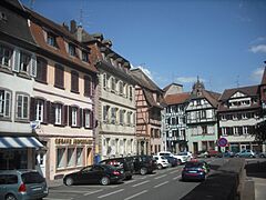
Sélestat is one of the richest and most varied smaller cities in Alsace when it comes to architecture. Even though it's only the 8th most populated town in the region, it has the third largest cultural heritage, after Strasbourg and Colmar. Sélestat has 35 buildings listed as historical monuments. It also has 119 other sites listed in the French cultural heritage register.
Museums in Sélestat

The Humanist Library has one of Europe's oldest and most complete collections of medieval writings and Renaissance books. Its main part is the almost untouched library of Beatus Rhenanus. He left his books to the city, and they have been kept there ever since. The library also holds books from Sélestat's Latin school, where Rhenanus and many other reformers studied around 1500. In 2011, Unesco added the library to its Memory of the World Register.
The library is open to both researchers and tourists. An exhibition shows some of its most important items. These include an 8th-century lectionary (a book of readings), the first books printed in Alsace, and a copy of the Cosmographiae Introductio which has the oldest mention of America. It also has a document from 1521 with the oldest record of a Christmas tree.
Sélestat also has a museum about bread and baking. It is home to the FRAC d'Alsace, a regional group that collects modern art. These artworks are often shown in temporary exhibits in Sélestat and other places in Alsace. FRAC has works by artists like Aurélie Nemours, Olivier Debré, Mario Merz, and Panamarenko.
Religious Buildings

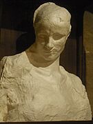
Sélestat has two large and amazing churches from the Middle Ages. St. Faith's Church is the oldest and a great example of Romanesque architecture. Its design is similar to buildings in the Rhine region and Lorraine. It was built in the second half of the 12th century, replacing an older building. The church was fixed up in the 19th century. During this work, a medieval death mask was found. Many believe it belongs to Hildegard of Eguisheim, who founded the church. It is now shown in a crypt (an underground room).
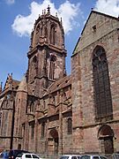
St. George's Church has always been the main church for the town. People often call it "the cathedral" because of its size, but it has never been the main church for a bishop (a diocese). Its construction began soon after 1200 and finished in the early 15th century. Its design is pure Gothic, except for a Romanesque side entrance. The choir, the last part to be finished, is the most impressive. It is lit by 288 stained glass panels, with 55 of them dating from the 15th century.
Most of the town's old convents (religious communities) are gone. The Dominican convent is the only one that still looks much like it did originally. It was built in the 13th century and still has its church and cloister (a covered walkway). The Franciscan convent was completely destroyed, except for the choir of its church, which is now a Protestant church. Sélestat also has an old granary that belonged to the Benedictine priory. There's also a 16th-century building built by the Knights Hospitaller.
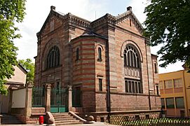
The synagogue was built in 1890. Its architecture is typical for the region, with a square shape and simple Romanesque-style decorations. Its cupola (dome) was destroyed in 1940 by the Nazis and was never rebuilt. The Jewish cemetery, outside the old town, opened in 1622. It has several gravestones from the 18th century that show Christian art influences.
-
The death mask in St. Faith's.
-
St. George's Church.
-
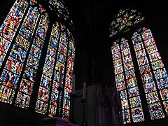
Stained-glass windows in St. George's.
-
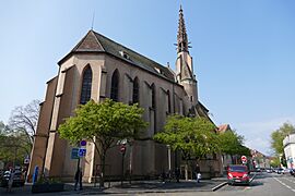
The Protestant church.
-
The synagogue.


Civil and Military Buildings

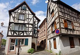
The old town has many buildings from the medieval and Renaissance periods. The quai des Tanneurs ("tanners' quay") is one of the most beautiful streets in Alsace. A stream used to flow down the middle of the street until the early 1900s. This was left over from the smelly tanning trade, which needed lots of flowing water to treat animal skins. Most of the old tanner houses are from the Middle Ages. They have tall attics to dry leather in a well-aired space. In nearby streets, rue des Oies ("geese street") and rue des Veaux ("calf street"), many houses were covered with plaster in the 19th century to hide the wooden frames, which were thought to look too old-fashioned.
Several large townhouses (called hôtels particuliers) are from the Renaissance period. Most have oriel windows, which are common in German Renaissance architecture. The grandest of these belonged to the Ebersmunster abbey and has a large three-story granary. The Ziegler house has a beautiful oriel that shows how much wealthy people at that time were interested in ancient times. The oriel partly reflects Vitruvius's ideas about architecture and shows portraits of four important figures from ancient history. Baroque architecture can be seen on some later townhouses from the 17th and 18th centuries. French classical architecture, with its main feature, the mansard roof, was widely used in the 18th century. To save money, buildings were still built with wooden frames. But since this was seen as too German and rustic, they were often covered to look like stone.

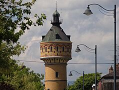
The German period (1871–1918) left some examples of Wilhelminism in the city's buildings. This grand style mixes different older styles, including Romanesque, Gothic, and neoclassical. Notable buildings include the post office (1884), the courthouse (1900), the Koeberlé high school (1913), and the water tower (1906). The water tower (50 meters or 164 feet tall) was inspired by the one in Deventer, Netherlands.
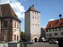
The medieval city walls, built in stages between the 13th and 16th centuries, were torn down after France took over in the 17th century. However, four towers survived. The Tour des Sorcières ("witches' tower"), which was a gate and a jail, is the tallest. The Tour de l'Horloge ("clock tower") was also part of a gate originally. The clock and its fancy roof were added in 1614. Two much smaller towers can also be seen, one near the Ill river and another built into a later house. All these remaining parts are from the 13th century.
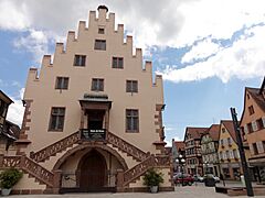
New walls were built by Tarade and Vauban in the 17th century. These were then destroyed in 1874. Only small parts remain: two bastions (strong parts of a wall) and the Porte de Strasbourg ("Strasbourg gate"). This gate is a good example of French architecture from the time of Louis XIV. Sélestat still has two old arsenals (places for weapons): Sainte-Barbe on the main square (1470) and Saint-Hilaire (1518). The first, with a large, toothed gable, is a fine example of Gothic architecture.
-
Rue Koeberlé.
-
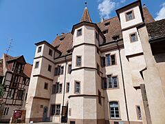
Hôtel d'Ebersmunster.
-
One of the many squares.
-
The water tower.
-
Tour des Sorcières.
-
Arsenal Ste Barbe.


Town Archives
The town's archives (archives municipales) in Sélestat keep and show many old documents. These include royal charters from the 13th century. Most famously, they have a record from 1521 that contains the first written mention of the Christmas tree.
Illwald Forest Nature Reserve

The Illwald forest became a regional nature reserve in 2013. It covers 1,855 hectares (4,584 acres), which is almost half of Sélestat's land. It is one of the largest riparian forests (forests along a river) in France. It lies on the Ill river, which forms a complex network of waterways there. The area often floods and is typical of the Grand Ried, a flat region between the Ill and the Rhine rivers. This area acts as a natural overflow for the two rivers.
Common trees here are oaks, willows, and alders, which can grow in wet soil. Because the groundwater is very close to the surface, the soil rarely freezes in winter. Also, droughts rarely happen in summer. The nature reserve also has meadows and areas of reeds. Common animals include many types of birds like storks, curlews, and harriers. There are also amphibians and mammals like beavers. The reserve is home to France's largest population of fallow deer. These animals were brought to the area in 1854.
The Illwald has three chapels that were once places for religious journeys. The Schnellenbuhl chapel was built by Jesuits in 1683. Our Lady of the Oaks dates back to the 15th century but was rebuilt after a fire in 1920. Our Lady of Peace was built in 1960. St. Anthony was founded in 1280 but rebuilt in 1930.
Other Cultural Events
.jpg)
Sélestat has been the home of the Agence culturelle d'Alsace ("cultural agency of Alsace", ACA) since 1976. Since 1982, Sélestat has also been the home of FRAC Alsace, the Alsace branch of the Fonds régional d'art contemporain ("Regional Contemporary art fund"), managed by the ACA. A biennale (an event held every two years) focusing on contemporary art takes place in autumn since 1984. It has featured artists like Daniel Buren, Ben Vautier, Sarkis Zabunyan, and Agnès Varda. Since 2006, Sélestat has been the home of Archéologie Alsace. This group carries out and records archaeological surveys and digs in Alsace.
Every year since 1927, Sélestat has held a large flower parade through its old town. This "corso fleuri" is one of the biggest flower shows in eastern France. New floats are made each year around a theme and decorated only with dahlias. A carnaval parade is also held in March. This is a very old tradition started by the town's butchers. Sélestat also has festivals for electronic music (Epidemic Experience) and funny cartoons (Sélest'ival). There's also a spring fun fair and a summer medieval reenactment with a market and a parade.
The cultural center Les Tanzmatten, designed by Rudy Ricciotti, opened in 2000. It serves as the town's hall for concerts and performances, as well as for exhibitions, trade fairs, and weddings.
Sports in Sélestat
Sélestat Alsace Handball is a well-known French handball club. It was started in 1967. FC Sélestat, the football (soccer) club, was founded in 1906.
Famous People
Born in Sélestat
- Martin Bucer, German Protestant reformer
- Fabienne Keller, French politician
- Jacques Paul Klein, French-American Diplomat and General
- Eugène Koeberlé, French surgeon
- Heinrich Kramer, German inquisitor
- Johannes Mentelin, German printer
- Beatus Rhenanus, German humanist
- Charles Sitzenstuhl, French politician
- Joseph Wackenthaler, French organist and composer
- Nicolas-Joseph Wackenthaler, French organist and composer
- Jakob Wimpfeling, German humanist
Connected to Sélestat
- Ludwig Dringenberg (died in Sélestat)
- Frédéric Fiebig, painter (lived and died in Sélestat)
- Thierry Omeyer (played professionally for Sélestat)
- François Ignace Schaal (died in Sélestat)
Sister Cities
Sélestat is connected with these cities:
 Charleroi, Belgium, since 1959
 Waldkirch, Germany, since 1966
 Grenchen, Switzerland, since 1988
 Dornbirn, Austria, since 2006
See also
 In Spanish: Sélestat para niños
