
Sainte-Marie-aux-Mines facts for kids
Quick facts for kids
Sainte-Marie-aux-Mines
|
||
|---|---|---|

Church of Saint Louis
|
||
|
||

Sainte-Marie-aux-Mines
Location in France

Sainte-Marie-aux-Mines
Location in Grand Est
|
||
| Country | France | |
| Region | Grand Est | |
| Department | Haut-Rhin | |
| Arrondissement | Colmar-Ribeauvillé | |
| Canton | Sainte-Marie-aux-Mines | |
| Intercommunality | CC du Val d'Argent | |
| Area
1
|
45.23 km2 (17.46 sq mi) | |
| Population
(2014)
|
5,129 | |
| • Density | 113.398/km2 (293.70/sq mi) | |
| Time zone | UTC+01:00 (CET) | |
| • Summer (DST) | UTC+02:00 (CEST) | |
| INSEE/Postal code |
68298 /68160
|
|
| Elevation | 326–1,210 m (1,070–3,970 ft) (avg. 375 m or 1,230 ft) |
|
| 1 French Land Register data, which excludes lakes, ponds, glaciers > 1 km2 (0.386 sq mi or 247 acres) and river estuaries. | ||
.svg)

Sainte-Marie-aux-Mines is a small town, also known as a commune, located in eastern France. It is part of the Haut-Rhin department. In 2015, about 5,136 people lived there. This town is known for its beautiful natural surroundings and a rich history, especially related to mining.
Contents
Exploring the Geography
Sainte-Marie-aux-Mines is nestled within the Vosges Mountains. These mountains are a famous range in eastern France.
The Val d'Argent Valley
The valley where Sainte-Marie-aux-Mines is found is called the Val d'Argent. This name means "Silver Valley." It's a special place because it includes five different towns. These towns are Aubure, Lièpvre, Rombach-le-Franc, and Sainte-Croix-aux-Mines.
Discovering Local Areas
Sainte-Marie-aux-Mines has many smaller areas or neighborhoods within it. Some of these include:
- Adelspach
- Altenberg
- Bourgonde
- Brifosse
- Clésio
- la Côte d'Échéry
- Échéry
- Faunoux
- Fenarupt
- Fertrupt (Fordelbach)
- Haut de Faîte
- la Haute Broque
- le Haycot
- Hergauchamps
- Mongoutte
- la Petite Lièpvre (Kleinleberau)
- le Petit Haut
- le Rauenthal (le Fond-nu)
- Saint-Philippe
- Saint-Pierre sur l'Hâte
- Surlattes (Zillhardt)
Related Places
Images for kids
-
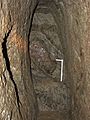
The Mine Gabe Gottes
-
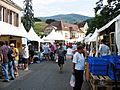
One of the Sainte-Marie-aux-Mines old streets full of mineral and fossil stands during the Mineral & Gem show.


See also
 In Spanish: Sainte-Marie-aux-Mines para niños
