Kluisbergen facts for kids
Quick facts for kids
Kluisbergen
|
|||
|---|---|---|---|

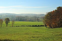
Typical Flemish Ardennes landscape
|
|||
|
|||
| Country | Belgium | ||
| Community | Flemish Community | ||
| Region | Flemish Region | ||
| Province | East Flanders | ||
| Arrondissement | Oudenaarde | ||
| Area | |||
| • Total | 30.38 km2 (11.73 sq mi) | ||
| Population
(2018-01-01)Lua error in Module:Wd at line 1575: attempt to index field 'wikibase' (a nil value).
|
|||
| • Total | Lua error in Module:Wd at line 1,575: attempt to index field 'wikibase' (a nil value). | ||
| Postal codes |
9690
|
||
| Area codes | 055 | ||
| Website | www.kluisbergen.be | ||
Kluisbergen is a town in Belgium. It's located in the province of East Flanders. The Scheldt river flows along its border.
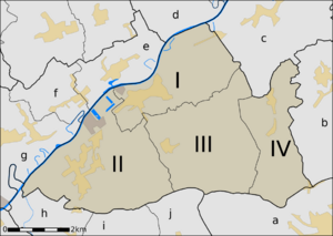
Kluisbergen is made up of four smaller towns. These are Berchem, East Flanders, Kwaremont, Ruien, and Zulzeke. They all joined together in 1971.
In 2021, about 6,682 people lived here. The total area of Kluisbergen is about 30.38 square kilometers. Ruien is the biggest town within Kluisbergen. It has some great outdoor places to visit.
Kluisbergen is also home to the "Kluisbos" forest. This forest has two very old standing stones. These stones date back to the time of the Roman Empire.
Contents
What Towns Make Up Kluisbergen?
Kluisbergen is made up of four main towns:
| I | Berchem |
| II | Ruien |
| III | Kwaremont |
| IV | Zulzeke |
Which Towns Are Nearby?
Kluisbergen is surrounded by several other towns and municipalities. Here are some of its neighbors:
| a | Ronse |
| b | Nukerke (Maarkedal) |
| c | Melden (Oudenaarde) |
| d | Elsegem (Wortegem-Petegem) |
| e | Kerkhove (Avelgem) |
| f | Waarmaarde (Avelgem) |
| g | Avelgem (Avelgem) |
| h | Orroir (Mont-de-l'Enclus) |
| i | Amengies (Mont-de-l'Enclus) |
| j | Russeignies (Mont-de-l'Enclus) |
What is the Landscape Like?
The Scheldt river forms the northwestern border of Kluisbergen. This area is quite flat. As you travel south or southeast, the land slowly becomes more hilly. This continues all the way to the southern border.
What Are the Main Hills?
Kluisbergen has three important hills:
- The Kluisberg is mostly located between Ruien and Orroir. It also stretches towards Kwaremont.
- The Paterberg is found in the middle of Kwaremont.
- The Hotondberg is on the border of Zulzeke and Ronse. It is the highest point in all of East Flanders.
These three hills are the westernmost hills of the Flemish Ardennes.
Things to Do and See
The Flemish Ardennes region is famous for its steep hills. Many of these hills have forests growing on their sides. Kluisbergen is well-known for these hills.
Why is Kluisbergen Popular for Cyclists?
The hills of Kluisbergen play a big role in the Tour of Flanders. This is a very famous cycling race. Because of this, the area is very popular with cyclists.
Are There Hiking Trails?
Yes! The town uses its many field trails for hiking routes. You can also join organized hiking tours.
What is Kwaremont Known For?
Kwaremont has a special title: "Artist Village." This is because many painters live there. You can also find many art galleries in Kwaremont.
See also
 In Spanish: Kluisbergen para niños
 | Roy Wilkins |
 | John Lewis |
 | Linda Carol Brown |


