Chastre facts for kids
Quick facts for kids
Chastre
|
|||
|---|---|---|---|

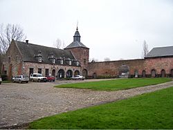
Chastre town hall
|
|||
|
|||
| Country | Belgium | ||
| Community | French Community | ||
| Region | Wallonia | ||
| Province | Walloon Brabant | ||
| Arrondissement | Nivelles | ||
| Area | |||
| • Total | 31.27 km2 (12.07 sq mi) | ||
| Population
(2018-01-01)Lua error in Module:Wd at line 1575: attempt to index field 'wikibase' (a nil value).
|
|||
| • Total | Lua error in Module:Wd at line 1,575: attempt to index field 'wikibase' (a nil value). | ||
| Postal codes |
1450
|
||
| Area codes | 010 | ||
| Website | www.chastre.be | ||
Chastre is a French-speaking town in Belgium. It is located in Wallonia, which is a region in Belgium, and is part of the province of Walloon Brabant.
The name Chastre comes from an old word, castra, which meant "fortress" or "fortified camp." This word came from Latin, where castrum meant a "fortified place."
Chastre is a mix of countryside and residential areas, meaning people live there but there are also many farms and green spaces. About 7,684 people live in Chastre. The town is made up of seven smaller villages: Chastre, Villeroux, Blanmont, Cortil-Noirmont, Gentinnes, and Saint-Géry. An old Roman road, called the Chaussée Brunehaut, runs through Chastre. This road used to connect two ancient cities, Bavay and Cologne.
Chastre is located between the towns of Ottignies-Louvain-la-Neuve and Gembloux. It's about 40 kilometers from Brussels, the capital of Belgium. You can easily reach Chastre by road or by train. A small river called the Orne flows through Chastre. This river and its smaller streams create beautiful landscapes, with many old farmhouses still being used today. The highest point in Chastre is 165 meters above sea level. Chastre is also "twinned" with two other places: Lespignan in France and Saint-Denis-sur-Richelieu in Canada. This means they have a special friendship and often share cultural events.
Contents
History of Chastre
In the early 900s, a part of Cortil, one of Chastre's villages, was owned by a person named Saint Guibert. In 936, he gave this land to Gembloux Abbey, a monastery he had just started. This gift was officially confirmed by Otto I, Holy Roman Emperor, in 946.
During the time when France controlled parts of Belgium, Chastre was part of a region called the Dyle department.
Postal History
The first post office in Chastre, called Chastre-Villeroux, opened on May 10, 1876. Later, post offices opened in Gentinnes on April 28, 1905, and in Blanmont on November 27, 1908.
Since at least October 1990, Chastre has had the postal code 1450.
What is a Coat of Arms?
Chastre received its official coat of arms on July 4, 1978. A coat of arms is a special design or symbol that represents a family, a town, or an organization. Chastre's coat of arms is the same as the one used by the former municipality of Chastre-Villeroux-Blanmont. They received it on April 22, 1969. The design includes lozenges, which are diamond shapes. These shapes come from the Kessel family, who were the last lords (important landowners) of Blanmont, and also from the Onyn family, who were the last lords of Chastre.
Geography of Chastre
Where is Chastre Located?
Chastre is located along the N4 road, about halfway between Ottignies-Louvain-la-Neuve and Gembloux. You can also get there by train, as the SNCB line 161 has stops at Blanmont and Chastre. Buses from the TEC company also serve the area. Chastre is surrounded by other towns like Walhain-Saint-Paul, Gembloux, Mont-Saint-Guibert, Sombreffe, and Villers-la-Ville.
Rivers in Chastre
Two lovely small rivers flow through Chastre: the Orne and the Houssière. The Orne river starts in Bertinchamps and flows through the villages of Cortil, Noirmont, Chastre, and Blanmont. It then passes by Mont-Saint-Guibert before joining the Dyle river. The Houssière river starts near Gentinnes, flows through Villeroux, and then joins the Orne river at Mont-Saint-Guibert. These rivers flow through a high plateau area, which is mostly between 145 and 155 meters high.
Nature in Chastre
Even though Chastre has a lot of green areas, its natural environment has changed over time. It used to be mainly farmland, but as more people have moved there, the area has become more developed. The number of farms is decreasing. Because Chastre is located between Brussels and Namur and has good road and train connections, its countryside has seen a lot of building and development over the last 30 years.
Population of Chastre
As of November 1, 2019, Chastre had 7,684 people living there. This means there were about 245.73 people for every square kilometer of land, given that the total area of Chastre is 31.27 square kilometers.
See also
 In Spanish: Chastre para niños
 | Sharif Bey |
 | Hale Woodruff |
 | Richmond Barthé |
 | Purvis Young |


