
Image: Lolo NF Map

Size of this preview: 800 × 551 pixels. Other resolutions: 320 × 220 pixels | 7,884 × 5,427 pixels.
Original image (7,884 × 5,427 pixels, file size: 14.47 MB, MIME type: image/jpeg)
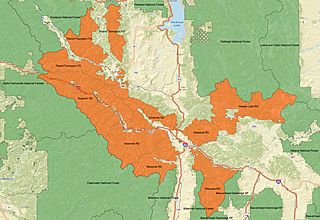
Description: A map of Lolo National Forest in Montana. The MIssoula, Ninemile, Plains/Thompson, and Seeley Lake Ranger Districts of the forest are in orange. Surrounding national forests, including Beaverhead-Deerlodge, Bitterroot, Clearwater, Flathead, Helena, Idaho Panhandle, Kootenai, and Lewis and Clark are in green. This map was made using ARCMAP 10.1, and all data are in the public domain. Forest Service boundary data are from the US Forest Service FSGeodata Clearinghouse
Title: Lolo NF Map
Credit: Own work
Author: Fredlyfish4
Usage Terms: Creative Commons Attribution-Share Alike 3.0
License: CC BY-SA 3.0
License Link: https://creativecommons.org/licenses/by-sa/3.0
Attribution Required?: Yes
Image usage
The following page links to this image:

All content from Kiddle encyclopedia articles (including the article images and facts) can be freely used under Attribution-ShareAlike license, unless stated otherwise.