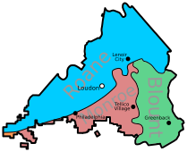
Image: Loudon County Creation

Size of this PNG preview of this SVG file: 209 × 170 pixels. Other resolution: 295 × 240 pixels.
Original image (SVG file, nominally 209 × 170 pixels, file size: 89 KB)
Description: A map of the Loudon County showing the counties from which it was formed. Modern cities are shown for reference. Note that the orange section in the southwest was gained from McMinn County around 1951.
Title: Loudon County Creation
Credit: Own work
Author: Leviavery
Usage Terms: Creative Commons Zero, Public Domain Dedication
License: CC0
License Link: http://creativecommons.org/publicdomain/zero/1.0/deed.en
Attribution Required?: No
Image usage
The following page links to this image:

All content from Kiddle encyclopedia articles (including the article images and facts) can be freely used under Attribution-ShareAlike license, unless stated otherwise.
