
Image: MH370 radar
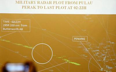
Description: Image from Malaysian military radar that, purportedly, shows Malaysia Airlines Flight 370 as it travels over the Strait of Malacca. The image is being presented to family members of passengers on the flight who were gathered at Lido Hotel Beijing. The white circle in the center-left of the image appears to highlight a spot where the aircraft was not detected by radar. The left segment of the flight's path follows air route N571 between waypoints VAMPI & MEKAR.
Title: MH370 radar
Credit: Original publication: http://photo.china.com.cn/news/2014-03/21/content_31863360.htm Immediate source: http://ogleearth.com/2014/03/mh370-updated-route-final-radar-plot/ Highest resolution: http://s1.ibtimes.com/sites/www.ibtimes.com/files/2014/03/21/mh370-search-briefing-3.jpg (2982x2286 1,868kB) sha1sum=fc2b1dcd1d8ebca600d0578e14b7fe3eb5d88a00 by_line= © Kim Kyung Hoon / Reuters creator=KIM KYUNG-HOON title=MALAYSIA-AIRLINES/ reuters_id=RTR3HZHB source=X01368 fixture=GM1EA3L14WB01 transmission_id=PEK707
Author: The photographer was Kim Kyung Hoon / Reuters. The author(s) of the slide itself is unclear.
Usage Terms: Fair use of copyrighted material in the context of Malaysia Airlines Flight 370
License: Fair use
License Link: //en.wikipedia.org/wiki/File:MH370_radar.jpeg
Image usage
The following page links to this image:
