
Image: Manhattan NYC OpenStreetMap 2023-08-21

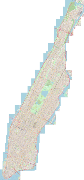
Description: OpenStreetMap map (as of August 21, 2023) of Manhattan Island, New York City. Manhattan Island, with its length of 21 km (13 mi) and its width of 3.7 km (2.3 mi), at its widest point, was shaped by the Commissioners' Plan of 1811, which laid out a grid plan over most of the island: 30 m (100 feet) wide avenues running north-south, and 18 m (60 feet) wide numbered streets running east–west, with about 61 m (200 feet) between each pair of streets, resulting in each combined street and block adding up to about 79 m (260 feet), so there are almost exactly 20 blocks per mile. Fifteen crosstown streets were designated as 30 m (100 feet) wide: 14th, 23rd, 34th, 42nd, 57th, 72nd, 79th, 86th, 96th, 106th, 116th, 125th, 135th, 145th and 155th streets.
Later, between 1857 and 1876, Central Park was added. Since 1951, the island hosts the headquarters of the United Nations. This map shows Manhattan as of August 21, 2023, according to OpenStreetMap.
Author: OpenStreetMap
Usage Terms: Creative Commons Attribution-Share Alike 3.0
License: CC-BY-SA-3.0
License Link: http://creativecommons.org/licenses/by-sa/3.0/
Attribution Required?: Yes
Image usage
The following page links to this image:
