
Image: Map Byzantine Empire 1045

Size of this PNG preview of this SVG file: 800 × 554 pixels. Other resolution: 320 × 222 pixels.
Original image (SVG file, nominally 1,300 × 900 pixels, file size: 335 KB)
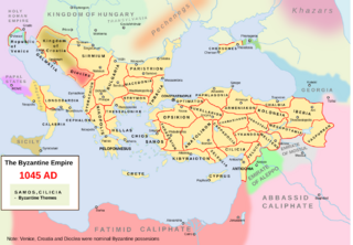
Description: Own work. The Byzantine empire and its neighbours in 1045. Byzantine administrative divisions included. Source> Stelian Brezeanu> O istorie a Imperiului Bizantin, Bucharest 1981. The map at page 110. Please write on the talk page if I misspelled the name of some themes. An available derivative work is a cropping showing only the central Balkans: :Image:Byzantine Macedonia 1045CE.svg.
Title: Map Byzantine Empire 1045
Credit: Own work
Author: Andrei nacu at English Wikipedia
Usage Terms: Public domain
License: Public domain
Attribution Required?: No
Image usage
The following page links to this image:

All content from Kiddle encyclopedia articles (including the article images and facts) can be freely used under Attribution-ShareAlike license, unless stated otherwise.