
Image: Map Deployment Mortar Fleet1862

Size of this preview: 800 × 484 pixels. Other resolutions: 320 × 194 pixels | 2,235 × 1,353 pixels.
Original image (2,235 × 1,353 pixels, file size: 229 KB, MIME type: image/jpeg)
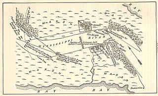
Description: Map depicting the positions of Porter’s Mortar fleet during the bombardment of Fort Jackson, April 16 to the 24th. Printed by the Government printing office in 1904 as part of the Official Records of the Union and Confederate Navies. (Page 277)
Title: Map Deployment Mortar Fleet1862
Credit: Official Records of the Union and Confederate Navies Series I, V.18, 1904, Page 277
Author: Frank (talk) 02:13, 10 April 2010 (UTC)
Permission: Work of the U.S. Government Printing Office 1904
Usage Terms: Public domain
License: PD
Attribution Required?: No
Image usage
The following page links to this image:

All content from Kiddle encyclopedia articles (including the article images and facts) can be freely used under Attribution-ShareAlike license, unless stated otherwise.