
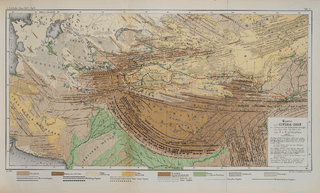
Image: Map of Central Asia with trade routes and movements, von Richthofen

Description: Map of Central Asia for overview of trade routes and movements from 128 BC to 150 AD
Title: Map of Central Asia with trade routes and movements, von Richthofen
Credit: F. von Richthofen (1877). China: Ergebnisse eigener Reisen und darauf gegründeter Studien. Band 1, Einleitender Theil [China: Expedition results and studies based thereupon. Volume 1, Introductory Part]. Berlin: Verlag von Dietrich Reimer. As reproduced in James D. Sidaway & Chih Yuan Woon (2017). Chinese Narratives on “One Belt, One Road” (一带一路) in Geopolitical and Imperial Contexts. The Professional Geographer 69(4), 591-603. doi: 10.1080/00330124.2017.1288576
Author: F. von Richthofen (1833–1905)
Usage Terms: Public domain
License: Public domain
Attribution Required?: No
Image usage
The following page links to this image:
