
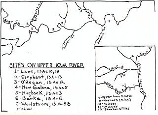
Image: Map of Upper Iowa River Oneota Site Complex

Size of this preview: 800 × 586 pixels. Other resolutions: 320 × 234 pixels | 1,989 × 1,457 pixels.
Original image (1,989 × 1,457 pixels, file size: 518 KB, MIME type: image/jpeg)
Description: Map of archaeological sites on the Upper Iowa River in Allamakee County, Iowa
Title: Map of Upper Iowa River Oneota Site Complex
Credit: Oneota Sites on the Upper Iowa River, The Missouri Archaeologist, vol. 21, no. 2-4, p. 1-181
Author: Wedel, Mildred Mott
Usage Terms: Public domain in the United States
License: PD-US
License Link: //en.wikipedia.org/wiki/File:Map_of_Upper_Iowa_River_Oneota_Site_Complex.jpeg
Image usage
The following 2 pages link to this image:

All content from Kiddle encyclopedia articles (including the article images and facts) can be freely used under Attribution-ShareAlike license, unless stated otherwise.