
Image: Map of part of Manitoba and the Canadian North-West Territories - Alberta, Assiniboia and Saskatchewan shewing system of land survey and the lines of the Canadian Pacific Railway CTASC
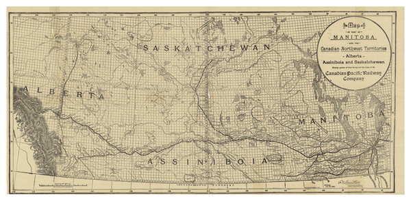
Description: Survey map of Canadian Pacific Railway Company lines through Manitoba, Saskatchewan and Alberta. Railway routes are outlined and the stations along them named. First Nations reserves are marked throughout with "I.R." for "Indian Reserve." Bodies of water are named.
Title: Map of part of Manitoba and the Canadian North-West Territories : Alberta, Assiniboia and Saskatchewan shewing system of land survey and the lines of the Canadian Pacific Railway
Credit: York University Libraries, Clara Thomas Archives & Special Collections, Historical map collection, HMC0006. http://digital.library.yorku.ca/islandora/object/yul:1153570
Author: Lott, C. S.
Usage Terms: Public domain
License: Public domain
Attribution Required?: No
Image usage
The following page links to this image:
