
Image: Mapa del Magreb (1956)

Size of this PNG preview of this SVG file: 582 × 599 pixels. Other resolution: 233 × 240 pixels.
Original image (SVG file, nominally 1,700 × 1,750 pixels, file size: 556 KB)
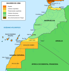
Description: Territories, colonies, and protectorates in Morroco as of 1956.
Title: Mapa del Magreb (1956)
Credit: Own work based on: File:Mapa de África Occicdental hasta 1956.png File:Saharaoccidentales.svg
Author: Milenioscuro
Permission: This file was derived from: Morocco (full) (+claims - POLISARIO hatched), administrative divisions - de - monochrome.svg
Usage Terms: Creative Commons Attribution-Share Alike 4.0
License: CC BY-SA 4.0
License Link: https://creativecommons.org/licenses/by-sa/4.0
Attribution Required?: Yes
Image usage
The following page links to this image:

All content from Kiddle encyclopedia articles (including the article images and facts) can be freely used under Attribution-ShareAlike license, unless stated otherwise.
.svg)