
Image: Martellus world map

Size of this preview: 800 × 554 pixels. Other resolutions: 320 × 221 pixels | 2,169 × 1,501 pixels.
Original image (2,169 × 1,501 pixels, file size: 2.69 MB, MIME type: image/jpeg)
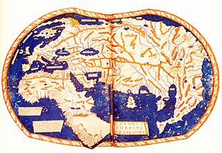
Description: The world map of "Henricus Martellus Germanus" (Heinrich Hammer the German), Florence 1490-92. The first map with the Dragon Tail. It is a mixture of Ptolemy, recent Portuguese discoveries and unknown sources. Displays the Cape of Good Hope, rounded by Bartolomeo Dias in 1488.
Title: Martellus world map
Credit: Insularium Illustratum (Account of the Islands of the Mediterranean)
Author: Heinrich Hammer the German ("Henricus Martellus Germanus")
Usage Terms: Public domain
License: Public domain
Attribution Required?: No
Image usage
The following page links to this image:

All content from Kiddle encyclopedia articles (including the article images and facts) can be freely used under Attribution-ShareAlike license, unless stated otherwise.