
Image: Mitchellmap-1755-telliquo
No higher resolution available.
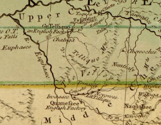
Mitchellmap-1755-telliquo.jpg (528 × 410 pixels, file size: 75 KB, MIME type: image/jpeg)
Description: The Unicoi Mountain area as presented on John Mitchell's "Map of the British and French Dominions in North America," published in 1755. Mitchell calls the Unicoi Mountains the "Telliquo Mountains." The Overhill Cherokee towns are shown in the top left, the Middle towns on the right, and the Valley towns at the bottom. The "Euphasee River" is now the Hiwassee River, and the "Tannassee River" is now the Little Tennessee River. The map is currently on file in the Map Collections of the U.S. Library of Congress.
Title: Mitchellmap-1755-telliquo
Credit: http://memory.loc.gov/cgi-bin/map_item.pl
Author: John Mitchell
Usage Terms: Public domain
License: Public domain
Attribution Required?: No
Image usage
The following page links to this image:

All content from Kiddle encyclopedia articles (including the article images and facts) can be freely used under Attribution-ShareAlike license, unless stated otherwise.