
Image: Morgenthau Plan map

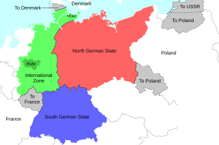
Description: Map of the 1944 Morgenthau Plan, which would have seen Germany totally demilitarised and divided into three areas: a Northern state, a Southern state, and a de-industrialised International Zone in the west, administered by "an international security organization, to be established by the United Nations". The International Zone included the Ruhr area, regarded as Germany's industrial heartland, and the important naval port of Kiel. The intention was to prevent Germany from ever again being able to develop military industry or wage war. In addition, the Saar region and surrounding area was to be ceded to France; most of Silesia and southern East Prussia to Poland; northern East Prussia to the USSR; and northern Schleswig to Denmark.
Title: Morgenthau Plan map
Credit: Own work
Author: Erinthecute
Usage Terms: Creative Commons Attribution-Share Alike 4.0
License: CC BY-SA 4.0
License Link: https://creativecommons.org/licenses/by-sa/4.0
Attribution Required?: Yes
Image usage
The following 2 pages link to this image:
