
Image: Mpumalanga population density map

Size of this PNG preview of this SVG file: 617 × 599 pixels. Other resolution: 247 × 240 pixels.
Original image (SVG file, nominally 1,015 × 986 pixels, file size: 906 KB)
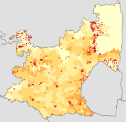
Description: Population density map of Mpumalanga province of South Africa, from the 2011 Census, at the "Small Area" level. <1 inhabitant/km² 1–3 inhabitants/km² 3–10 inhabitants/km² 10–30 inhabitants/km² 30–100 inhabitants/km² 100–300 inhabitants/km² 300–1000 inhabitants/km² 1000–3000 inhabitants/km² >3000 inhabitants/km² Projection is Albers Equal-Area Conic, with standard parallels at 25.5° S and 31.5° S, and origin at 28.5° S 25.5° E.
Usage Terms: Public domain
Image usage
The following page links to this image:

All content from Kiddle encyclopedia articles (including the article images and facts) can be freely used under Attribution-ShareAlike license, unless stated otherwise.