
Mpumalanga facts for kids
Quick facts for kids
Mpumalanga
iMpumalanga
iPumalanga |
|||
|---|---|---|---|
|
|||
| Motto(s):
Omnia labor vincit (Labour will conquer all)
|
|||

Location of Mpumalanga in South Africa
|
|||
| Country | South Africa | ||
| Established | 27 April 1994 | ||
| Capital | Mbombela | ||
| Districts |
List
Gert Sibande
Nkangala Ehlanzeni |
||
| Government | |||
| • Type | Parliamentary system | ||
| Area | |||
| • Total | 76,495 km2 (29,535 sq mi) | ||
| Area rank | 8th in South Africa | ||
| Highest elevation | 2,331 m (7,648 ft) | ||
| Population
(2022)
|
|||
| • Total | 5,142,216 | ||
| • Rank | 6th in South Africa | ||
| • Density | 67.2229/km2 (174.1065/sq mi) | ||
| • Density rank | 3rd in South Africa | ||
| Population groups (2022) | |||
| • Black | 95.3% | ||
| • White | 3.6% | ||
| • Coloured | 0.6% | ||
| • Indian or Asian | 0.5% | ||
| • Other | 0.5% | ||
| Languages (2022) | |||
| • Swazi | 30.5% | ||
| • Zulu | 27.8% | ||
| • Tsonga | 10.6% | ||
| • Pedi | 10.3% | ||
| • Southern Ndebele | 9.9% | ||
| • Afrikaans | 3.2% | ||
| • Southern Sotho | 2.3% | ||
| • English | 1.5% | ||
| Time zone | UTC+2 (SAST) | ||
| ISO 3166 code | ZA-MP | ||
| HDI (2019) | 0.675 medium · 7th of 9 |
||
| GDP | US$58.2 billion | ||
| Website | https://www.mpg.gov.za/ | ||


Mpumalanga is one of South Africa's nine provinces. Its name means "East" or, more poetically, "The Place Where the Sun Rises" in the Nguni languages. This is because it is located in the eastern part of South Africa.
Mpumalanga borders two other countries: Eswatini and Mozambique. It also connects with four other South African provinces: Limpopo, Gauteng, the Free State, and KwaZulu-Natal. The capital city of Mpumalanga is Mbombela.
The province was created in 1994, after the end of apartheid. It was formed by joining the old Eastern Transvaal area with several former homelands, like KaNgwane and KwaNdebele.
Contents
History
Ancient Times

People have lived in the Mpumalanga region for a very long time. Archaeologists have found evidence of human ancestors from 1.7 million years ago. Ancient rock paintings and tools show that early humans lived here as hunter-gatherers.
Around 28,000 years ago, people were already mining iron ore in this area. Later, they also mined tin, copper, and gold. The famous Lydenburg Heads, which are clay sculptures of heads, were made here around 500 A.D. They are the oldest Iron Age artworks found in Africa south of the equator.
Between the 1500s and 1800s, large farming and trading societies grew. They built stone-walled villages and traded with Portuguese sailors at Maputo Bay. During this time, groups like the Swazi, Pedi, and Ndebele made this region their home.
The Colonial Era
In 1845, Dutch-speaking settlers, known as Boers, arrived in the area during the Great Trek. This led to conflicts over land with the local kingdoms. The Pedi and Zulu people fought hard to defend their land against the new settlers.
The discovery of gold near towns like Pilgrim's Rest and Barberton brought many more people to the region. It became an important area for mining and trade. During the Second Boer War, many important battles were fought in this region.
The Apartheid Years
In 1948, the South African government introduced a system called apartheid. These laws separated people by race and were very unfair to Black South Africans. The government forced Black people to leave their homes and move to special areas called "homelands."
Many people in Mpumalanga resisted these unfair laws. In 1959, people across the country boycotted potatoes from Bethal to protest the terrible working conditions of Black farmworkers there. By the 1980s, protests and resistance across South Africa helped lead to the end of apartheid.
A New Beginning
On April 27, 1994, South Africa held its first democratic election where all races could vote. The province of Mpumalanga was officially formed on this day. It was first called "Eastern Transvaal," but the name was changed to Mpumalanga in 1995.
After apartheid, the government started a program to return land to Black communities who had been forced to leave. This process has helped many people, but it has also faced challenges.
Geography

The tall Drakensberg mountains run through the middle of Mpumalanga. This range divides the province into two different landscapes.
- The Highveld is a high-altitude grassland in the west. It has cool weather and is good for farming.
- The Lowveld is a low-altitude, subtropical savanna in the east. It is much warmer and is home to the famous Kruger National Park.
Some of the oldest rocks on our planet are found in the Barberton area. These rocks contain some of the earliest signs of life, from over 3 billion years ago!
Climate
Because of its different landscapes, Mpumalanga has different climates. The Lowveld is warm and subtropical, while the Highveld is much cooler, with cold winters.
Most of the rain comes from summer thunderstorms. The Highveld often gets frost in the winter, but the Lowveld usually stays frost-free. Climate change is causing temperatures to rise and rainfall to become less predictable in the province.

Amazing Plants and Animals
Mpumalanga is home to an incredible variety of plants and animals. Many of these species are endemic, which means they are not found anywhere else in the world.
Unique Species of Mpumalanga
- Robust Golden Mole: A small, shiny mammal that lives underground.
- Treur River Barb: A small fish that lives in the province's rivers.
- Barberton Sugarbush: A type of protea plant that is threatened by mining.
- Komati Waterberry: A type of tree that grows near water.
Protecting Wildlife

Mpumalanga has many nature reserves to protect its special plants and animals.
- Kruger National Park: One of the largest and most famous game reserves in Africa.
- Blyde River Canyon Nature Reserve: Home to a stunning canyon, one of the largest in the world.
- Great Limpopo Transfrontier Park: A huge international park that connects Kruger Park with parks in Mozambique and Zimbabwe.
- Lowveld National Botanical Garden: A beautiful garden in Mbombela that showcases the region's plants.
How the Province is Governed
Mpumalanga has its own provincial government, which is led by a Premier. The laws for the province are made by the Mpumalanga Provincial Legislature. The members of the legislature are elected by the people of Mpumalanga every five years.
Since 1994, the African National Congress (ANC) has been the main political party in power. Other parties, like the Economic Freedom Fighters and the Democratic Alliance, are also part of the legislature.
Municipalities
.svg)
Mpumalanga is divided into three large areas called district municipalities. These districts are then divided into 18 smaller local municipalities, which manage towns and cities.
District Municipalities
- Ehlanzeni District
- Gert Sibande District
- Nkangala District
Economy

The economy of Mpumalanga is based on farming, mining, and tourism.
Farming and Food
Mpumalanga is like a giant garden for South Africa. Its different climates allow farmers to grow a wide variety of crops. These include maize, sunflowers, sugar cane, citrus fruits, and nuts. The province is also a major producer of beef, chicken, and wool. Forestry is also important, with large forests of pine and eucalyptus trees near towns like Sabie.
Mining for Treasure
The ground in Mpumalanga is rich in minerals. Gold was first discovered here in the 1880s. Today, coal is the most important mineral. Mpumalanga produces over 80% of South Africa's coal. Most of this coal is used in power stations to generate electricity for the country. However, the large number of coal power stations causes air pollution, which is a major environmental challenge.
Fun Things to Do
Mpumalanga is a very popular place for tourists to visit.
- Go on a Safari: You can visit the world-famous Kruger National Park to see the "Big Five" animals: lions, leopards, elephants, rhinos, and buffalos.
- See Amazing Views: The Blyde River Canyon offers incredible scenery, including the Three Rondavels rock formations and Bourke's Luck Potholes.
- Explore Caves: The Sudwala Caves are among the oldest known caves in the world and are fascinating to explore.
- Have an Adventure: You can also go hiking, mountain biking, and river rafting.
Culture and People
.jpg)
Mpumalanga is home to people from many different cultures, including Swazi, Ndebele, Tsonga, Zulu, and Pedi. This mix of cultures makes the province a vibrant place.
The Ndebele people are famous for their beautiful, brightly colored houses and traditional clothing. The artist Esther Mahlangu is known worldwide for her modern take on Ndebele art. The province is also the birthplace of many famous South African musicians, like Ray Phiri and Pretty Yende.
Every year, the city of Mbombela hosts the Innibos festival, a large arts festival with music, theater, and crafts.
People of Mpumalanga


According to the 2022 census, over 5.1 million people live in Mpumalanga.
The most common language spoken at home is siSwati (30.5%). Other major languages include isiZulu (27.8%), Xitsonga (10.6%), Sepedi (10.3%), and isiNdebele (9.9%).
About 95.3% of the people in Mpumalanga are Black African. The rest of the population is made up of White (3.6%), Coloured (0.6%), and Indian or Asian (0.5%) people.
Gallery
-
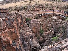
Bourke's Luck Potholes.
-
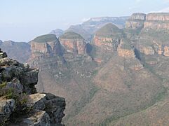
Three Rondavels of the Blyde River Canyon.
-
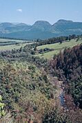
The Drakensberg escarpment.
-
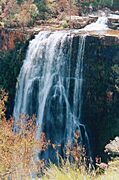
Lisbon Falls.
-
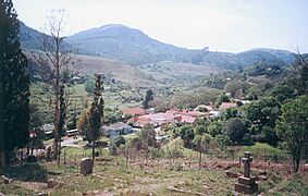
The historic town of Pilgrim's Rest.
-
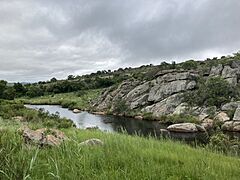
The Treur River flowing into the Blyde River.

.jpg)


See also
 In Spanish: para niños
- List of heritage sites in Mpumalanga
- List of speakers of the Mpumalanga Provincial Legislature
- Care For Wild rhinoceros sanctuary
