
Image: Mt Rainier from ISS 2018
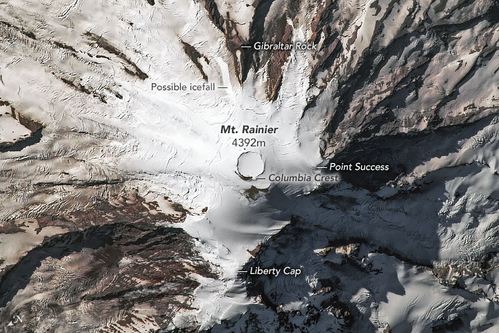
Description: Mount Rainier is the tallest mountain in the Cascade Range, standing 14,410 feet (4,392 meters) above sea level. Viewed from the side, its highest point might appear to be Point Success, Liberty Gap, or the crater rim. The nadir view, however, gives a clear view of Columbia Crest—a small mound of snow north of the crater rim, and the mountain’s true highest point. The nadir perspective also provides a clear view of the volcano’s crater. Black rocks ring the snow- and ice-filled crater, which measures more than 1,000 feet (300 meters) across. This clearly defined crater is ringed by a second, less distinct crater. With 25 named glaciers flowing down its flanks and patches of perennial snow, the mountain stays white year-round. In some areas, ice is forced around huge, long walls of rock known as “cleavers”; one of the most prominent is Gilbraltar Rock. Scientists have documented the gradual loss of the mountain’s perennial ice, which lost almost 2 percent of its area between 2009 and 2015. Not all changes are gradual. Just two days before this photograph was acquired, an icefall on Ingraham Glacier sent blocks of ice and rubble careening down 1,000 vertical feet (300 meters) along a popular climbing route. The event, large enough to be detected on seismographs, occurred at night and no climbers were injured. The modern mountain is the result of about half a million years of growth amid periods of volcanic activity. Cascade Range volcanoes, including Mount Rainier, are the result of oceanic crust sinking below North America, causing the release of water and melted rock. During the past 2600 years the mountain has erupted about a dozen times, the largest of which occurred about 2200 years ago. Small summit explosions were last reported in 1894, but have not been confirmed.
Title: Mt Rainier from ISS 2018
Credit: https://earthobservatory.nasa.gov/images/145548/mount-rainier?src=eoa-iotd
Author: ISS Crew Earth Observations Facility
Permission: Public domainPublic domainfalsefalse This file is in the public domain in the United States because it was solely created by NASA. NASA copyright policy states that "NASA material is not protected by copyright unless noted". (See Template:PD-USGov, NASA copyright policy page or JPL Image Use Policy.) Warnings: Use of NASA logos, insignia and emblems is restricted per U.S. law 14 CFR 1221. The NASA website hosts a large number of images from the Soviet/Russian space agency, and other non-American space agencies. These are not necessarily in the public domain. Materials based on Hubble Space Telescope data may be copyrighted if they are not explicitly produced by the STScI.[1] See also Template:PD-Hubble and Template:Cc-Hubble. The SOHO (ESA & NASA) joint project implies that all materials created by its probe are copyrighted and require permission for commercial non-educational use. [2] Images featured on the Astronomy Picture of the Day (APOD) web site may be copyrighted. [3] The National Space Science Data Center (NSSDC) site has been known to host copyrighted content. Its photo gallery FAQ states that all of the images in the photo gallery are in the public domain "Unless otherwise noted."
Usage Terms: Public domain
License: Public domain
Attribution Required?: No
Image usage
The following page links to this image:
