
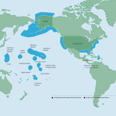
Image: NOAA Map of the US EEZ

Size of this PNG preview of this SVG file: 599 × 600 pixels. Other resolution: 240 × 240 pixels.
Original image (SVG file, nominally 612 × 613 pixels, file size: 1.93 MB)
Description: Map of the US's Exclusive Economic Area, including Navassa Island but not Bajo Nuevo Bank and Serranilla Bank.
Title: NOAA Map of the US EEZ
Credit: http://www.gc.noaa.gov/documents/2011/012711_gcil_maritime_eez_map.pdf
Author: National Oceanic and Atmospheric Administration
Usage Terms: Public domain
License: Public domain
Attribution Required?: No
Image usage
The following 2 pages link to this image:

All content from Kiddle encyclopedia articles (including the article images and facts) can be freely used under Attribution-ShareAlike license, unless stated otherwise.