
Image: North Wales Map

Size of this PNG preview of this SVG file: 501 × 599 pixels. Other resolution: 201 × 240 pixels.
Original image (SVG file, nominally 512 × 612 pixels, file size: 167 KB)
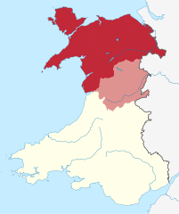
Description: Map of the undefined region of North Wales, following the borders of the 6 Northern local authorities of Wales, Montgomeryshire (part of Powys, shaded in lighter tone) is sometimes considered North Wales due to historical definitions.
Title: North Wales Map
Credit: This vector image includes elements that have been taken or adapted from this file:
Author: Dank · Jay
Usage Terms: Creative Commons Attribution-Share Alike 4.0
License: CC BY-SA 4.0
License Link: https://creativecommons.org/licenses/by-sa/4.0
Attribution Required?: Yes
Image usage
The following page links to this image:

All content from Kiddle encyclopedia articles (including the article images and facts) can be freely used under Attribution-ShareAlike license, unless stated otherwise.