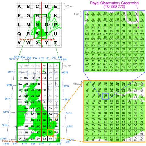
Image: Ordnance Survey National Grid

Description: Illustration of the Ordnance Survey National Grid coordinate system, with Royal Observatory Greenwich as an example. Squares with two-letter codes in bold have significant land in Great Britain. The background map is from http://commons.wikimedia.org/wiki/File:British_National_Grid.svg while the latitude and longitude grid is based on an illustration in "A guide to GNSS": http://www.nottingham.ac.uk/grace/documents/resources/glossariestutorials/globalnavigationsatellitesystems.pdf by the University of Nottingham GNSS Research Applications Centre of Excellence.
Title: Ordnance Survey National Grid
Credit: British National Grid.svgNorthwestern Europe on OSGB 1936 Datum.svg
Author: cmglee, Strebe, MansLaughter, Alexrk2 from naturalearthdata, Pethrus and nandhp
Usage Terms: Creative Commons Attribution-Share Alike 3.0
License: CC BY-SA 3.0
License Link: https://creativecommons.org/licenses/by-sa/3.0
Attribution Required?: Yes
Image usage
The following page links to this image:

