
Image: Pearlmap2

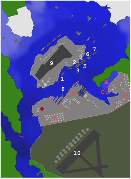
Description: Map of ships and port facilities in Pearl Harbor during the attack. This text based legend is preferred: <21 ft 22-23 ft 29 ft 30-32 ft 33-34 ft 34-35 ft 36-37 ft 38-39 ft 40-41 ft 42-48 ft >49 ft City Army base Navy base Or alternately, can be used with this image: (Image:Phdepth.png) 1:USS California 2:USS Maryland 3:USS Oklahoma 4:USS Tennessee 5:USS West Virginia 6:USS Arizona 7:USS Nevada 8:USS Pennsylvania 9:Ford Island NAS 10:Hickam field A:Oil storage tanks B:CINCPAC C:Submarine base D:Naval yard
Title: Pearlmap2
Credit: self-made using map from http://www.navsource.org/Naval/ as a reference.
Author: Anynobody
Usage Terms: Creative Commons Attribution-Share Alike 3.0
License: CC BY-SA 3.0
License Link: http://creativecommons.org/licenses/by-sa/3.0
Attribution Required?: Yes
Image usage
The following 2 pages link to this image:
