Ford Island facts for kids
|
Native name:
Mokuʻumeʻume (Island of Attraction) Poka ʻAilana (Ford Island) |
|
|---|---|
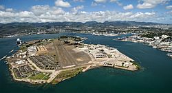
Ford Island, located within
Pearl Harbor, Oahu, Hawaii |
|
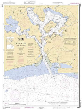
Nautical chart of Pearl Harbor showing Ford Island in the northeast section
|
|
| Geography | |
| Location | Oahu, Hawaii |
| Coordinates | 21°21′50″N 157°57′37″W / 21.36389°N 157.96028°W |
| Adjacent bodies of water | East Loch, Pearl Harbor |
| Area | 441 acres (178 ha) |
| Length | 1.5 mi (2.4 km) |
| Width | 0.75 mi (1.21 km) |
| Administration | |
|
United States
|
|
| Demographics | |
| Population | 368 (2000) |
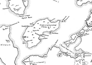
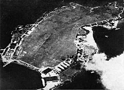
Ford Island (Hawaiian: Poka ʻAilana) is a small island in the middle of Pearl Harbor, Oahu, in the U.S. state of Hawaii. It has been known by other names like Rabbit Island and Little Goats Island. Its native Hawaiian name is Mokuʻumeʻume, which means "island of attraction."
The island was originally about 334 acres in 1825. In the 1930s, the United States Navy made it bigger by adding dirt and sand from the harbor, increasing its size to 441 acres. This also helped to make Pearl Harbor deeper for larger ships.
Ford Island was once a place for ancient Hawaiian rituals. Later, it was owned by different people, including Dr. Seth Porter Ford, who gave the island its current name. It was then turned into a sugarcane farm.
In 1916, the U.S. Army bought part of the island for airplanes. By 1939, the U.S. Navy took over the whole island. It became a very important place for the U.S. Navy in the Pacific Ocean. Ford Island was right in the middle of the attack on Pearl Harbor by the Imperial Japanese fleet on December 7, 1941.
Today, Ford Island is a National Historic Landmark. It hosts military activities and a Pacific Tsunami Warning Center. The island has also been featured in movies like Tora! Tora! Tora! and Pearl Harbor. Many tourists visit the USS Arizona memorial and the USS Missouri museum located there.
Contents
Exploring Ford Island's Geography
Ford Island is located inside Pearl Harbor, on the southern side of Oʻahu in Hawaii. Pearl Harbor is divided into three main water areas: the West Loch, Middle Loch, and East Loch. Ford Island sits in the center of the East Loch.
The island is about 1.5 miles (2.4 km) long and 0.75 miles (1.2 km) wide. As mentioned, it grew from 334 acres (135 hectares) to 441 acres (178 hectares) between 1930 and 1940. This was done by using soil and sand dug from the harbor. The island is mostly flat, rising only 5 to 15 feet (1.5 to 4.6 m) above the water. A long bridge, about 4,672 feet (1,424 m) long, connects Ford Island to the larger island of Oʻahu.
The soil on Ford Island is made up of volcanic ash, weathered rock, and coral. There are also two smaller islands nearby, called Mokunui and Mokuiki.
Ford Island's Environmental Cleanup
In 1991, the Navy found some chemicals in the soil, groundwater, and marine sediment on Ford Island. These chemicals likely came from old fuel tanks, a landfill, and storage bunkers used in the past.
To make the area safe, the Navy decided to cover the affected spots with clean soil and special plants that help prevent erosion. This cleanup system was finished in 1996. The Navy also installed wells to keep an eye on the groundwater.
Wildlife and Plants on Ford Island
The animals on Ford Island are similar to those found at Naval Station Pearl Harbor. Most of the wildlife are invasive species, meaning they are not native to the island. These include animals like house mice, mongooses, and different types of rats.
You might also see common birds like house sparrows, Java sparrows, and common mynahs. An endangered native owl, called the pueo (a type of short-eared owl), has also been seen hunting on the island.
Most of the plants on Ford Island are not native either. For example, Francisco de Paula Marín brought edible cacti from California to the island in the late 1700s. In ancient times, the harbor around the island was important to Hawaiians because it had many fish, such as mullet and Hawaiian anchovy.
The National Park Service and the United States Fish and Wildlife Service help manage the historic battlefields at Pearl Harbor and Ford Island.
A Look Back at Ford Island's History
Ancient Hawaiian Traditions
Ancient Hawaiians called the island Mokuʻumeʻume. This name came from a special ceremony called ʻume that was held during the Makahiki festival. This ceremony was for married couples who were having trouble having children. The word moku means island, and ʻume means to attract or entice.
During the ʻume ceremony, people would sing around a bonfire. This activity was stopped by Christian missionaries in the 1830s.
The native Hawaiian people living in the area were known as Ke Awalau o Puʻuloa. They used the island to grow watermelons and gather pili grass for building thatched roofs. Hawaiian legends say that the goddess Kaʻahupahau made a rule on the island that no more killings should happen there.
Early Settlers and New Owners
Historians believe that Kamehameha I gave the island to Francisco de Paula Marín, a Spanish sailor, around 1818. Marín used the land to raise animals like sheep, hogs, goats, and rabbits, and grew plants he brought from other places.
In 1825, Admiral George Byron arrived in Hawaii and helped map Pearl River (now Pearl Harbor). His team called Ford Island "Rabbits Island" because of all the rabbits they saw there.
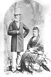
Over time, the island's ownership changed hands several times. In 1866, Dr. Seth Porter Ford married Caroline Jackson and took control of the island, renaming it Ford Island. After Dr. Ford's death, his son sold the island to the John Papa ʻĪʻī estate in 1891.
The Sugar Industry and Military Interest
Sugar was a very important export from Hawaii. In the 1870s, the U.S. military wanted to get control of a harbor in Hawaii for defense. They were especially interested in Pearl Harbor.
The U.S. government tried to get Ford Island in exchange for allowing Hawaiian sugar to be imported into the U.S. without taxes. However, many native Hawaiians did not want to sell their land, as they believed it was sacred.
In 1887, the United States began leasing Pearl Harbor. After some political changes in Hawaii, a treaty was signed in September 1887. This treaty allowed the U.S. to use Pearl Harbor.
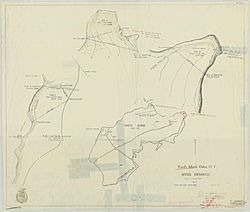
The Oahu Sugar Company leased about 300 acres (120 hectares) of Ford Island in 1899 to grow sugarcane. They used aqueducts to bring fresh water to the crops and transported the sugarcane by barge and rail to mills.
In the early 1900s, the U.S. military bought parts of Ford Island for gun batteries and an airfield. This led to the island becoming more important for military aviation.
The Army Air Service on Ford Island
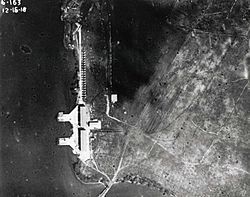
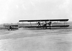
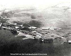
In 1917, the 6th Aero Squadron of the U.S. Army chose Ford Island for a new aviation base. They picked it because of its good access to water and winds. Soldiers worked hard to clear the island, removing hills and large rocks.
By 1918, all the main buildings, including hangars and a runway, were finished. In 1919, the airfield was named Luke Field, honoring Frank Luke, a World War I flying hero. The Army's presence on Ford Island helped develop civilian airports and flying in Hawaii.
The Navy also wanted a base in Hawaii and saw Ford Island as a great spot. In 1919, Naval Air Station Pearl Harbor was set up on the island. The island was divided, with the Army getting the west side and the Navy the southeast side.
| Army Air Force Aircraft at Luke Field | ||
|---|---|---|
| Dates | Unit | Aircraft |
| 1919–42 | 2nd Group (Observation) later 5th Group (Observation) | — |
| 1918–27 | 6th Aero Squadron later 6th Pursuit Squadron | N-9, R-6, HS2L, DH-4, JN-6, MB-3, Fokker D.VII |
| 1924–27 | 19th Pursuit Squadron | JN-6, MB-3, S.E.5, DH-4 |
| 1920–22, 1927–39 | 4th Aero Squadron later 4th Observation Squadron | DH-4, O-19, OA-1, B-12, P-12 |
| 1922–39 | 23d Squadron later 23d Bombardment Squadron | NBS-1, JN-6, DH-4 |
| 1923–39 | 72d Bombardment Squadron | DH-4, NBS-1, LB-5 |
| 1930–39 | 50th Observation Squadron later 50th Reconnaissance Squadron | O-19 |
In the 1930s, the Navy deepened Pearl Harbor so larger battleships and aircraft carriers could enter. This work also increased Ford Island's size to 441 acres (178 hectares).
From 1936 to 1940, Pan American used Ford Island as a refueling stop for its Clipper planes flying between the United States and Asia. In 1937, famous pilot Amelia Earhart crashed her plane on takeoff from Luke Field during her second visit.
| Naval aircraft at Naval Air Station Pearl Harbor in 1931 | ||
|---|---|---|
| Unit | Aircraft | |
| Patrol Squadron 1 | 6x T2D | |
| Patrol Squadron 4 | 12 PD-1 | |
| Patrol Squadron 6 | 6x T4M-1 6x T3M-2 |
|
| Reconnaissance Squadron 6 | 2x OL-8 1x O2U |
|
In 1939, the Army moved its operations to the new Hickam Army Airfield. Luke Field then became Naval Air Station Ford Island, fully under Navy control. During World War II, over 40,000 people lived or worked on the island.
The Attack on Pearl Harbor
In the 1930s, Imperial Japan was trying to expand its territory. The United States, Britain, and the Netherlands stopped selling important resources like aircraft fuel and steel to Japan. This affected Japan's ability to make war supplies. Japan decided to continue its plans but felt it needed to deal with the United States first.
On December 7, 1941, Ford Island was a key target during the Japanese attack on Pearl Harbor. The U.S. battleships were lined up along "Battleship Row" on the east side of Ford Island.
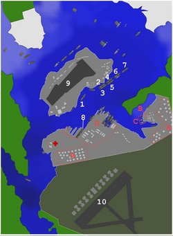 |
1:California A:Oil storage tanks |
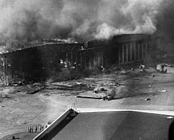
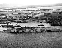
The first bombs hit Ford Island at 7:57 AM. Japanese torpedo planes attacked Battleship Row. Many torpedoes hit their targets, causing the USS Oklahoma and USS West Virginia to sink quickly.
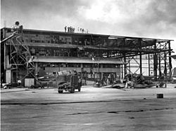
Bombs also hit hangars and other buildings on Ford Island. The most famous hit was on the USS Arizona, which exploded and sank, becoming the final resting place for many sailors. The USS Nevada tried to escape but was hit and had to be run aground to prevent it from blocking the harbor.
Some American planes returning from missions were accidentally shot down by American anti-aircraft guns during the confusion. Many planes on Ford Island were destroyed.
After the Attack
All seven battleships on Battleship Row were damaged. While some were repaired quickly, the Oklahoma and Arizona were completely lost. This attack greatly weakened the U.S. Pacific Fleet.
After the attack, the Navy worked to recover and repair the damaged ships. They used large winches on Ford Island to turn the Oklahoma upright. The entire salvage operation involved thousands of hours of work underwater to recover remains, weapons, and artifacts.
New facilities were built on Ford Island, including bomb shelters and a new control tower. The headquarters of the U.S. Pacific Fleet also moved to Ford Island.
By 1955, the Fleet Intelligence Center, Pacific (FICPAC) was set up on Ford Island. In 1966, Naval Air Station Ford Island was officially closed, and its operations moved elsewhere. However, the Navy continued to control the island.
In 1970, the runway on Ford Island was opened for civilian flight training, especially for military flying clubs. It also helped reduce air traffic at nearby Honolulu International Airport. The Third Fleet moved its headquarters to Ford Island in 1973, staying there until 1991.
| Ford Island Air Traffic Statistics | |||||||||||||||||||||||||
|---|---|---|---|---|---|---|---|---|---|---|---|---|---|---|---|---|---|---|---|---|---|---|---|---|---|
| 1970s | Year | 1970 | 1971 | 1972 | 1973 | 1974 | 1975 | 1976 | 1977 | 1978 | 1979 | ||||||||||||||
| Operations | N/A | 176,811 | 173,908 | 157,621 | 177,767 | 177,767 | |||||||||||||||||||
| 1980s | Year | 1980 | 1981 | 1982 | 1983 | 1984 | 1985 | 1986 | 1987 | 1988 | 1989 | ||||||||||||||
| Operations | 142,438 | 123,419 | 108,828 | 84,857 | 71,542 | 85,102 | 75,429 | 62,406 | 77,456 | 29,128 | |||||||||||||||
| 1990s | Year | 1990 | 1991 | 1992 | 1993 | 1994 | 1995 | 1996 | 1997 | 1998 | 1999 | ||||||||||||||
| Operations | 80,193 | 69,468 | 62,184 | 62,184 | 54,277 | 51,942 | 52,731 | 39,671 | 39,992 | 50,441 | |||||||||||||||
In 1999, all military and civilian flight activities at Ford Island ended. This was because a new civilian airport, Kalaeloa Airport, opened nearby.
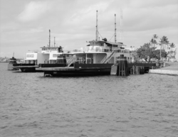
Before the Admiral Clarey Bridge was built, people accessed Ford Island by ferry. Two large diesel-powered ferries, Waa Hele Honoa and Moko Holo Hele, carried people and vehicles. Access to the island was limited to military personnel and their guests.
The Rebirth of Ford Island
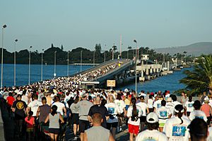
The Admiral Clarey Bridge, sometimes called "the bridge to nowhere" at first, was very important for the "rebirth" of Ford Island. It allowed for over $500 million in new development. The bridge connected the island to the main road, making it easier for families and workers to get there. It also helped build the $50 million Pacific Aviation Museum Pearl Harbor.
The Navy planned to build 500 homes for Navy families, a child-development center, and a Navy lodge on the island. While the Navy wanted to preserve important historic buildings, some groups were concerned that other historic parts, like the runway and old housing, might not be protected.
To support the new facilities, the island's sewage system was updated in 2001. In 2005, new power lines and fiber-optic cables were installed under the harbor, parallel to the bridge, to provide electricity and communication to the island.
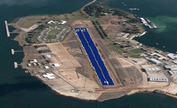
In 2013, the Navy planned to install many solar panels on the Ford Island runway. This was to help reduce the island's reliance on fossil fuels. However, the Pacific Aviation Museum opposed this plan because of the runway's historical importance. The Navy then decided to put the solar panels on other existing buildings around Pearl Harbor instead.
Ford Island's Present-Day Use
Ford Island is still actively used by the U.S. Navy. It hosts the Pacific Warfighting Center, which is used for military exercises and training. The Admiral Clarey Bridge also allowed for the construction of a new $331 million Pacific tsunami warning center, named after Senator Daniel Inouye. This center helps warn people about tsunamis.
The Sea-based X-band Radar (SBX-1), a large floating radar system, has visited Ford Island several times for maintenance. In 2013, the Navy opened a new $4 million training facility on Ford Island. This facility uses simulators and virtual reality to train sailors, which helps save money on real-world training exercises.
Memorials and Museums on Ford Island
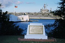
After the attack on Pearl Harbor, it was decided that the USS Arizona would remain at the bottom of the harbor as a memorial for those who died. The USS Arizona Memorial was built over the ship and dedicated in 1962. Visitors take a ferry to reach the memorial.
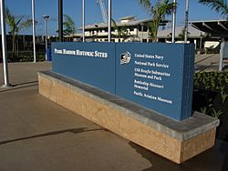
In 1964, the Navy facility at Pearl Harbor, including Ford Island, was named a National Historic Landmark. Several historic bungalows on the island are part of the Pearl Harbor National Memorial.
The battleship USS Utah, which was used as a target ship, also remains submerged off the island. In 1972, a memorial was dedicated to the fifty-eight men still inside the USS Utah.
In 1998, the USS Missouri battleship was brought to Ford Island and opened as a museum in 1999. On December 7, 2006, the Pacific Aviation Museum Pearl Harbor opened in Hangar 37. A memorial for the USS Oklahoma was dedicated in 2007 near the USS Missouri museum. The Pacific Aviation Museum is also working to restore the Ford Island control tower, which sent the first radio alert during the attack.
Ford Island in Film and Television
Ford Island has been a filming location for several movies and TV shows. The 1965 film In Harm's Way, starring John Wayne, was filmed there.
In 1970, the island's control tower was repainted for the movie Tora! Tora! Tora!, which showed the Pearl Harbor attack. During filming, a plane crash-landed on Ford Island, and this scene was included in the movie.
In April 2000, the movie Pearl Harbor was filmed on the island. The filmmakers brought vintage planes and ships to Ford Island for the movie. The control tower's operations room was even turned into a barracks for filming. The Pacific Aviation Museum hoped the movie would bring more attention to the historic tower.
In 2010, the TV series Hawaii Five-0 filmed an episode in a housing community on Ford Island. That same year, the USS Missouri was featured in the movie Battleship.
See also
 In Spanish: Isla Ford para niños
 | Delilah Pierce |
 | Gordon Parks |
 | Augusta Savage |
 | Charles Ethan Porter |


