
Image: Pietro Martire d'Anghiera Map of the Caribbean 1511 JCB

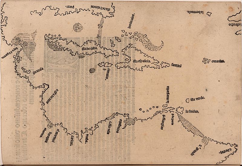
Description: A map of the Caribbean basin, including the islands of Hispaniola, Cuba, Jamaica, with the coast of Florida and Central America. Nautical elements include soundings. This is the first printed map specifically devoted to the Americas and the first mention of Bermuda on a map.
Title: Map of the Caribbean
Credit: John Carter Brown Library
Author: Peter Martyr d'Anghiera
Permission: This is a faithful photographic reproduction of a two-dimensional, public domain work of art. The work of art itself is in the public domain for the following reason: Public domainPublic domainfalsefalse This work is in the public domain in its country of origin and other countries and areas where the copyright term is the author's life plus 100 years or fewer. This work is in the public domain in the United States because it was published (or registered with the U.S. Copyright Office) before January 1, 1927. This file has been identified as being free of known restrictions under copyright law, including all related and neighboring rights. https://creativecommons.org/publicdomain/mark/1.0/PDMCreative Commons Public Domain Mark 1.0falsefalse The official position taken by the Wikimedia Foundation is that "faithful reproductions of two-dimensional public domain works of art are public domain". This photographic reproduction is therefore also considered to be in the public domain in the United States. In other jurisdictions, re-use of this content may be restricted; see Reuse of PD-Art photographs for details.
Usage Terms: Public domain
License: Public domain
Attribution Required?: No
Image usage
The following page links to this image:
