
Image: Plan of Yocemento, Mill and Grounds, July 1907

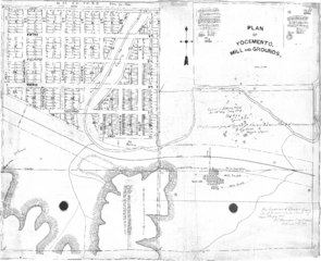
Description: I. M. Yost's Plan of the Yocemento cement mill and community plat, registered July 15, 1907. The right half of the plat corresponds to the B. F. Replogle parcel in the Standard Atlas of Ellis County, Kansas, 1905.[1] Replogle insisted for compensation for construction of a road from Hays to this mill over his property.[2] This then identifies the creek to the southwest of the mill as Replogle creek, which is today crossed by the railroad with a substantial plate girder bridge by the switch to the grain elevator. This image was originally uploaded in pdf format, but failed to render. It was recently converted to png format using the Export PDF function of Adobe Acrobat Standard DC. The question of correct licencing was raised on Wikipedia and again on Commons. No interest in the question was shown. However, at the time, the image did not render; so, assessment was not immediately convenient. Since the content on the geodataportal is public domain, the only real question is whether Commons has the expectation that the 1997 vacation content be redacted.
Title: Plan of Yocemento, Mill and Grounds, July 1907
Credit: http://www.geodataportal.net/plats/Yocemento.pdf
Author: I. M. Yost
Usage Terms: Public domain
License: Public domain
Attribution Required?: No
Image usage
The following page links to this image:
