
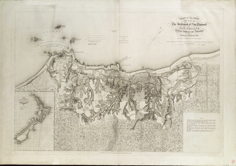
Image: Plan of the town and part of the settlement of New Plymouth, New Zealand, selected surveyed and delineated by Fred. A.Carrington; late Chief Surveyor of the settlement. RMG F0149f
Description: Plan of the town and part of the settlement of New Plymouth, New Zealand, selected surveyed and delineated by Fred. A.Carrington; late Chief Surveyor of the settlement.Single sheet. Engr. Scale: 1:15 840. Cartographic Note: Ungraduated. North at 30 degrees. Scale 4 inches to the mile. Contents Note: Shows the land divided into rectangular plots with a street grid in the town. Text extols the beauty and resources of the country. Inset: The Islands of New Zealand [ca. 1:15 000 000]. STK263:2/8 New Plymouth NZ by Carrington
Title: Plan of the town and part of the settlement of New Plymouth, New Zealand, selected surveyed and delineated by Fred. A.Carrington; late Chief Surveyor of the settlement. RMG F0149
Credit: http://collections.rmg.co.uk/collections/objects/540718
Author: Carrington, Fred A; John Brain
Permission: The original artefact or artwork has been assessed as public domain by age, and faithful reproductions of the two dimensional work are also public domain. No permission is required for reuse for any purpose. The text of this image record has been derived from the Royal Museums Greenwich catalogue and image metadata. Individual data and facts such as date, author and title are not copyrightable, but reuse of longer descriptive text from the catalogue may not be considered fair use. Reuse of the text must be attributed to the "National Maritime Museum, Greenwich, London" and a Creative Commons CC-BY-NC-SA-3.0 license may apply if not rewritten. Refer to Royal Museums Greenwich copyright.
Usage Terms: Public domain
License: Public domain
Attribution Required?: No
Image usage
The following page links to this image:
