
Cartography of New Zealand facts for kids


Cartography is the art and science of making maps. The Cartography of New Zealand is the story of how maps of New Zealand have been made over time. This includes surveying the land and drawing maps.
Mapping in New Zealand started when Abel Tasman arrived in the mid-1600s. Since then, mapping and surveying have grown a lot. Today, New Zealand uses a global system based on GPS. This system helps create very accurate maps.
At first, surveyors measured points on the ground. They marked out areas with stakes. Later, in the late 1800s, they used a method called triangulation. This method uses triangles to measure distances and positions. The New Zealand Institute of Surveyors was created in 1888 to help guide this work.
The country was divided into 28 'Meridional Circuits'. Each circuit had a known starting point. Other places could be measured from this point. This system worked well for local areas. But it was harder for surveys that crossed different circuits.
To fix this, the whole country was mapped using a special triangulation survey. This happened between 1909 and 1947. This led to the New Zealand Geodetic Datum 1949 and the New Zealand Map grid. Later, mapping used photos from planes and then satellites. The New Zealand Geodetic Datum 2000 replaced the 1949 version. Today, New Zealand maps are sold as digital files. You can also buy printed maps at 1:50,000 and 1:250,000 scales.
Contents
How New Zealand Was Mapped
Before Europeans arrived, Māori people divided New Zealand into areas for their tribes (Iwi) and smaller groups (hapu). They used natural landmarks to define these areas. They remembered these boundaries through special chants and stories. Owning natural resources like fishing spots was often more important than owning the land itself. Land was held by custom, given as gifts, or taken through battle.
Māori did not have a tradition of drawing maps like Europeans. But early Polynesian explorers did make stick diagrams. These showed the distance and direction to islands. When European explorers first came to New Zealand, many places already had Māori names.
Early European Explorers
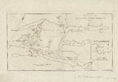
The first two European groups to map New Zealand were led by Abel Tasman and James Cook. Both were trying to find a huge continent called Terra Australis. They also gave New Zealand its first non-Māori place names. During this time, Māori also started drawing their own maps. These ranged from simple drawings in the sand to detailed sketches of the whole South Island.
Cook proved that Terra Australis did not exist. He made detailed maps of New Zealand. But his maps had two small mistakes. They showed Stewart Island as a peninsula (a piece of land almost surrounded by water). They also showed Banks Peninsula as an island. The French explorer Dumont d’Urville soon corrected the Banks Peninsula mistake.
These early detailed maps and reports of many animals brought sealers and whalers to New Zealand. Before 1840, there were no rules for selling land to European settlers. This often caused arguments, especially where tribal land ownership was unclear.
Mapping After the Treaty of Waitangi
After the Treaty of Waitangi in 1840, all New Zealand lands came under British rule. The treaty allowed Māori tribes to keep their traditional lands. Europeans who wanted to buy land had to work through a government group. If a deal was made, the buyer received a "crown grant." This gave them ownership under British law. Land purchases made before 1840 were called "old land claims." They also had to go through this same process. Many of these claims were made smaller than the original agreements.
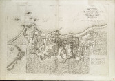
The British government created plans for settling New Zealand. Maps were made to mark out land and attract people to invest. At this time, Māori and Europeans were also negotiating land sales. When the Otago Gold Rush started and minerals were found near Nelson, geologists and surveyors were hired. They mapped the inland areas of New Zealand. By 1855, two ships, the Acheron and Pandora, had mapped New Zealand's coastline in great detail.
The job of "surveyor-general" was created in 1840. The first rules for surveying came in 1842. Surveyors had to give their licenses to the surveyor-general's office. They got them back when their survey was finished. In 1852, provinces were set up. Each province had its own survey department. But these departments often did not have enough money. Most failed to create a good system for surveys. This meant boundaries were not always clear. There were gaps and overlaps between different surveys.
Some small networks of triangulation points were set up. Some cities also created survey control points along known routes. Surveyors could use these as a base for local surveys. In Otago, the direction of true north was found at six points. Local surveys could be linked to these points. This made sure angle measurements were consistent. These areas were called "meridional circuits." This name is still used in New Zealand surveying today.
In 1875, Major H. S. Palmer wrote a report about the survey system. He said it was not good enough. He suggested that New Zealand should use one map projection. He also said there should be one system of reference points across the whole country. In 1876, the provinces were abolished. Their survey departments were combined. John Turnbull Thomson, the chief surveyor of Otago, became the surveyor-general for the new government survey department. Thomson set up meridional circuits across the country. He also changed how land records were identified and kept. By 1880, the small original triangulation networks had grown. They now covered all of New Zealand.
Modern Geodetic Surveys
After Major Palmer's report, triangulation was used across New Zealand. But it was not always accurate enough. In 1921, Surveyor-General W.T. Neill started work on a new system. This system would create very accurate reference points across New Zealand. In 1923, the first "baseline" was measured near Kaingaroa. From 1930 onwards, measurements were taken at night. This helped make them even more accurate. The longest measurement was 120 kilometres (75 miles) across Cook Strait.
Work continued during World War II. This project helped create topographical maps quickly for military use. The last field work was finished in early 1949. This system became known as the New Zealand Geodetic Datum 1949.
The 1949 system was updated in 2000. The new system was slightly shifted. This made it easier to use with GPS measurements. It was also designed to handle earthquakes and land movement better. This system is called the New Zealand Geodetic Datum 2000. It includes the NZ Transverse Mercator projection, which is used for topographical maps.
These mapping activities are why you see "trig stations" on top of many hills in New Zealand. These are special markers used by surveyors.
Queen's Chain
The "Queen's Chain" is an idea in New Zealand property law. It is a strip of public land, usually 20 metres (about 66 feet) wide. It runs along rivers, lakes, and the coastline. The idea was to make sure that land along a river or coast was not blocked off. This way, people could always get to the water.
These strips are not always complete. Their exact location today can be tricky to figure out. They exist in different forms, like road reserves or esplanade reserves. But they are not as widespread or consistent as some people might think.
How Surveying Works Today

In New Zealand, surveying land for property boundaries is guided by the Cadastral Survey Act 2002. This law sets up groups that deal with surveying. The surveyor-general creates specific rules for these surveys. The Land Transfer Act 1952 also affects how surveys are done.
A system called the Torrens system was introduced in 1870. This system keeps land ownership information in a central register. Before this, you had to check the history of many documents to prove ownership. The Torrens system made land titles very secure. It meant that only the registered owner could claim the land.
There is a separate system for land owned by Māori tribes. This is controlled by the Te Ture Whenua Maori (Maori Land) Act 1993. In 1980, about 4.5% of New Zealand's land was held under this Māori land system. This does not include land owned by Māori individuals under the general land system.
A surveyor who can legally sign plans for dividing land is called a licensed cadastral surveyor.
Surveying for construction projects is not controlled by the government in New Zealand. However, some surveying work might need to be approved by a registered professional surveyor. This can happen because of contracts or local council rules.
In New Zealand, surveyors use "whole circle (azimuth) bearings" for directions. Also, when writing coordinates, the "northing" (north-south position) is written before the "easting" (east-west position). This is different from many other parts of the world.
|
