Provinces of New Zealand facts for kids
Quick facts for kids Provinces |
|
|---|---|
| Also known as: Provincial Districts |
|
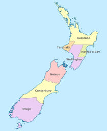 Provinces in 1858 |
|
| Category | Provinces |
| Location | Colony of New Zealand |
| Created | 3 May 1841 |
| Abolished | 1 November 1876 |
The provinces of New Zealand were like smaller governments within the country. They helped manage different parts of the Colony of New Zealand. These provinces were first set up in 1846 when New Zealand was a Crown colony, meaning it was directly ruled by the British Crown.
At first, there were two main provinces: New Ulster and New Munster. Each had its own leaders and rules. Later, in 1852, the provinces were changed and six new ones were created. By 1873, there were nine provinces. However, people started wanting a stronger central government. So, in 1875, the New Zealand Parliament decided to get rid of the provincial governments. They officially ended in November 1876. After this, New Zealand was divided into counties.
Even though the provinces were gone, their old names and boundaries are still used today. For example, they help decide the areas for some public holidays called "anniversary days."
Contents
New Zealand's Early Provinces
After the Treaty of Waitangi in 1840, New Zealand became a British colony. At first, it was part of New South Wales in Australia.
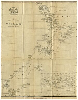
A special document from November 1840 gave the islands of New Zealand these names:
- New Ulster (the North Island)
- New Munster (the South Island)
- New Leinster (Stewart Island/Rakiura)
These names were just for geography. In May 1841, New Zealand became its own separate Crown Colony. This meant it was directly governed by Britain.
First Provinces: 1846-1853
In 1846, the British Parliament passed a law to create provinces in New Zealand. Governor George Edward Grey arrived in New Zealand in 1845. He thought the new law wouldn't work well.
Even so, Governor Grey announced the first provincial boundaries in March 1848:
- New Ulster covered the North Island, north of the Patea River.
- New Munster included the North Island south of the Patea River, the South Island, and Stewart Island.
Each of these provinces had a Lieutenant-Governor. This person was chosen by the main Governor. The provinces also had their own official seals.
Provinces with Self-Government: 1853–1876
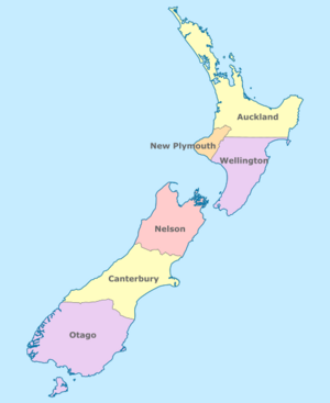
New provinces were formed by the New Zealand Constitution Act 1852. This law set up a system where the country had both a central government and smaller provincial governments. New Zealand was divided into six provinces: Auckland, New Plymouth, Wellington, Nelson, Canterbury, and Otago.
Each province had its own elected law-making group called a provincial council. They also elected a leader called a superintendent. The people of the province voted for these leaders.
The 1852 law also created a national government called the General Assembly. This included the Legislative Council, whose members were chosen by the Governor. It also had the House of Representatives, whose members were directly elected by the people.
These new provinces officially started on 17 January 1853. The first elections for these provinces happened at the same time as the national elections in 1853.
More Provinces Are Added
The 1852 law allowed for new provinces to be created later. As more European settlements grew, people in these areas wanted their own local governments. So, the General Assembly passed the New Provinces Act in 1858.
This new law made it easier for areas to become their own province. An area needed at least 1,000 European people. Also, 60% of the voters had to agree.
Because of this law:
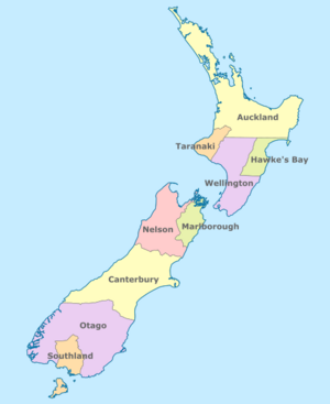
- Hawke's Bay Province separated from Wellington on 1 November 1858.
- Marlborough Province separated from Nelson on 1 November 1859.
- Southland Province separated from Otago on 1 April 1861.
Also, the New Plymouth province changed its name to Taranaki. Stewart Island, which wasn't part of any province before, joined Southland province in 1863.
Here's a list of the provinces and when they were formed:
| Province | Formed date | Formed from | Dissolution date |
|---|---|---|---|
| Auckland | 17 January 1853 | New Ulster | 1 November 1876 |
| New Plymouth | 17 January 1853 | New Ulster | 1 November 1876 |
| Hawke's Bay | 1 November 1858 | Wellington | 1 November 1876 |
| Wellington | 17 January 1853 | New Munster | 1 November 1876 |
| Nelson | 17 January 1853 | New Munster | 1 November 1876 |
| Marlborough | 1 November 1859 | Nelson | 1 November 1876 |
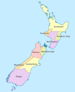
| Westland | 1 December 1873 | Canterbury | 1 November 1876 |
| Canterbury | 17 January 1853 | New Munster | 1 November 1876 |
| Otago | 17 January 1853 | New Munster | 1 November 1876 |
| Southland | 25 March 1861 | Otago | 5 October 1870 |
Why the Provinces Ended
From the very beginning, there was a lot of debate about New Zealand's provinces. Two main groups formed in the General Assembly. "Centralists" wanted a strong national government. "Provincialists" wanted strong regional governments.
The Centralists believed the provinces often acted only for their own benefit. For example, when building railways, three provinces built tracks that were different widths. This made it hard for trains to travel across the country. To fix this, a law in 1870 made all new railways use the same narrow track width.
A key figure was Julius Vogel, who was in charge of the country's money. In the 1870s, he started a huge plan called the "Great Public Works." This plan involved borrowing a lot of money to build roads, railways, and communication systems across the country. The central government managed these big projects. This made the provinces less powerful.
Vogel explained that the provinces struggled because they couldn't raise enough money on their own. They always had to ask the central government for help. He said their end was "only a question of time."
The provinces were finally ended by the Abolition of Provinces Act in 1875. This happened when Harry Atkinson was the Premier (like a Prime Minister). The provinces officially stopped existing on 1 January 1877.
What Replaced the Provinces?
After the provinces were abolished, they became known as "provincial districts." These districts didn't have any real power to govern. Instead, local government was given to elected borough and county councils. The Counties Bill of 1876 created 63 counties from the old provincial areas.
The old provincial boundaries were still used for some things. For example, they were used for the education boards set up by the Education Act of 1877. They were also used for the offices of some government departments, like the Department of Lands and Survey.
In 1989, the counties were replaced by larger district councils.
Provinces Today
The old provincial names are still important in New Zealand today.
Public Holidays
Some current "Provincial Anniversary Days" are still public holidays in New Zealand. These include: Auckland†, Taranaki†, Hawkes' Bay†, Wellington†, Marlborough†, Nelson†, Canterbury†, Westland†, Otago†, and Southland†. The dagger (†) means it was an original province.
Rugby and Other Uses
The old provincial districts also influence rugby union in New Zealand. The teams in the ITM Cup and Heartland Championship often represent these areas. Even though the names have changed, the term "provincial" is still used for rugby teams.
Some of the old names are also used for health administration districts. For example, there are health boards for Auckland†, Hawke's Bay†, Wellington†, Nelson (Marlborough)†, West Coast†, Canterbury†, and Southern (Otago)†.
The current regions of New Zealand and their councils were mostly formed in 1989. Many of these regions still use the names of the old provinces, such as Auckland†, Hawke's Bay†, Taranaki†, Wellington†, Nelson†, Marlborough†, West Coast†, Canterbury†, Otago†, and Southland†.
Sometimes, people use the word "provincial" to mean anything rural or outside the main cities. For example, a small town might be called "provincial." You might hear phrases like "out in the provinces" on TV weather reports.
See also
 In Spanish: Provincias de Nueva Zelanda para niños
 | Delilah Pierce |
 | Gordon Parks |
 | Augusta Savage |
 | Charles Ethan Porter |


