
Image: Roman Empire 125 political map

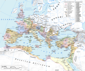
Description: Map of the Roman Empire in 125 during the reign of emperor Hadrian. Projection Lambert azimuthal-equal area. Central latitude: 45° N, central longitude: 20° E. X, Y origin offset - 0 Datum: ETRS89 Sources The physical map was made using the following public domain sources: Topography: NASA Shuttle Radar Topography Mission (SRTM30) data Shoreline, lakes and rivers: derived from Natural Earth data Additional references for the map content: Tacitus, Germania (ca. 100) Ptolemy, Geographia (ca. 140) Atlante storico DeAgostini, Instituto Geografico DeAgostini, 1998. pg. 35-41. Historischer Weltatlas, Dr. Walter Leisering, Marix Verlag, 2011. pg. 26-27 Történelmi világatlasz, Cartographia Kiadó, 2005. pg. 20-21. The Penguin Historical Atlas of Ancient Rome by Christopher Scarre, Penguin Historical Atlases, 1995. pg. 81. Software used GIS: Open JUMP GIS (open source): http://www.openjump.org/ GRASS GIS (open source): http://grass.osgeo.org/ Graphics editors: Inkscape (open source): http://inkscape.org/ GIMP (open source): http://www.gimp.org/
Title: Roman Empire 125 political map
Credit: Own work
Author: User:Andrein, with the assistance of EraNavigator
Permission: Any use of this map can be made as long as you credit me (Andrei N. – Wikimedia Commons user: Andrein) as the author and distribute the copies and derivative works under the same license as that the one stated below.
Usage Terms: Creative Commons Attribution-Share Alike 3.0
License: CC BY-SA 3.0
License Link: http://creativecommons.org/licenses/by-sa/3.0
Attribution Required?: Yes
Image usage
The following page links to this image:
