
Image: Ross Island Map USGS 250k

Size of this preview: 749 × 600 pixels. Other resolutions: 300 × 240 pixels | 2,106 × 1,686 pixels.
Original image (2,106 × 1,686 pixels, file size: 1.89 MB, MIME type: image/png)
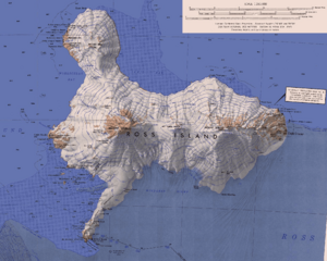
Description: Topographic map of Ross Island, Antarctica. ST 57-60/6* (extended). Scale 1:250,000. 1972. Lambert Conformal Conic, standard parallels. Compiled in 1962 from US Navy tricamera aerial photographs taken 1956-1960. Revised from US Navy tricamera photographs taken 1967-1970.
Title: Ross Island Map USGS 250k
Credit: http://usarc.usgs.gov/drg_dload.shtml
Author: USGS
Usage Terms: Public domain
License: Public domain
Attribution Required?: No
Image usage
The following page links to this image:

All content from Kiddle encyclopedia articles (including the article images and facts) can be freely used under Attribution-ShareAlike license, unless stated otherwise.