
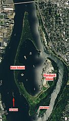
Image: Ross Island satellite labeled

Size of this preview: 341 × 599 pixels. Other resolutions: 136 × 240 pixels | 874 × 1,536 pixels.
Original image (874 × 1,536 pixels, file size: 346 KB, MIME type: image/jpeg)
Description: Satellite labelled map of Ross Island in Oregon
Title: Ross Island satellite labeled
Credit: https://viewer.nationalmap.gov/viewer/
Author: United States Geological Survey
Usage Terms: Public domain
License: Public domain
Attribution Required?: No
Image usage
The following page links to this image:

All content from Kiddle encyclopedia articles (including the article images and facts) can be freely used under Attribution-ShareAlike license, unless stated otherwise.