
Image: Ruscelli Nueva Hispania Tabula Nova 1561 UTA

Size of this preview: 778 × 600 pixels. Other resolutions: 311 × 240 pixels | 3,000 × 2,313 pixels.
Original image (3,000 × 2,313 pixels, file size: 9.26 MB, MIME type: image/jpeg)
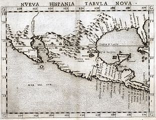
Description: Ruscelli's 1561 map of New Spain was an enlarged copy of fellow Venetian Giacomo Gastaldi's 1548 map of New Spain, but with a major difference: Ruscelli's map showed Yucatan correctly as a peninsula, not an island. Both were New World addendum maps for "modern" editions of the 2nd century Greek geographer Claudius Ptolemy's book on geography.
Title: Nueva Hispania Tabula Nova
Credit: Cartographic Connections: map / text
Author: Girolamo Ruscelli
Usage Terms: Public domain
License: Public domain
Attribution Required?: No
Image usage
The following 3 pages link to this image:

All content from Kiddle encyclopedia articles (including the article images and facts) can be freely used under Attribution-ShareAlike license, unless stated otherwise.