
Image: Sámova říše

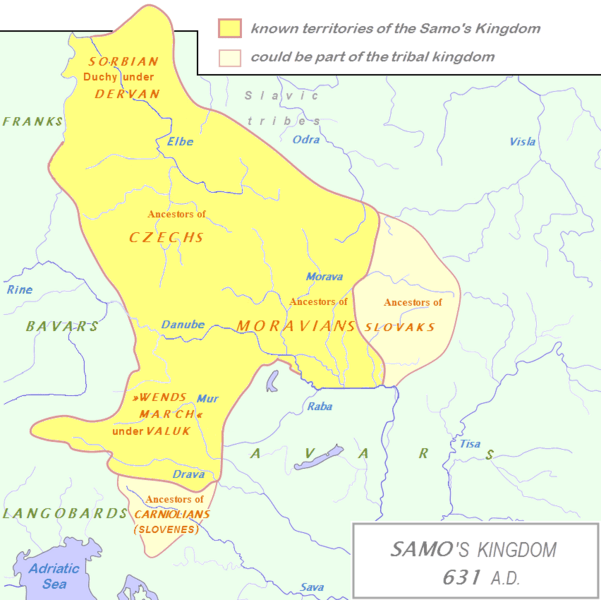
Description: Tribal Kingdom of Samo. Map is based on the maps in: Korošec, Paola (1990): Alpski Slovani-Die Alpenslawen, Ljubljana, Znanstveni institut Filozofske fakultete, unnamed map on the page 18; Šavli, Jožko (1995): Sovenija: Podoba evropskega naroda, Bilje, založba Humar, map Samovo kraljestvo on the page 19; Barford, Paul M. (2001): The Early Slavs, Cornell University Press, map on the page 356, named Geography of the Slav settlement of Polabia - concerning the location of Sorbs east of Saale; map IV on page 397 for Sorbian culture, Devinska Nova Ves culture and Avarian state. It is also based on descriptions in: Štih, Peter (2001): Ozemlje Slovenije v zgodnjem srednjem veku: osnovne poteze zgodovinskega razvoja od začetka 6. do konca 9. stoletja, Ljubljana, Filozofska fakulteta; page 30 - concerning the relationship between king Samo and the ancestors of Slovenians; Korošec, Paola (1990): Alpski Slovani-Die Alpenslawen, Ljubljana, Znanstveni institut Filozofske fakultete, page 17 – concerning the Sorbs and their duke Dervan. For eastern and southern extant of tribal kingdom: known territories are shown by the scheme of franco-slavic border and information about the conflicts with Avars is imlemented. The inclusion of Bohemian basin is followed. Contacts with Avars are reached through the territory of Moravians and Eastern Alps. The territories further east and south, which are in proximity of Avars, could be parts of tribal kingdom, too.
Title: Sámova říše
Credit: Waterways_of_SE_Central_Europe.svg
Author: Waterways_of_SE_Central_Europe.svg: Kmiki87 derivative work: Bostjan46 (talk)
Usage Terms: Public domain
License: Public domain
Attribution Required?: No
Image usage
The following 2 pages link to this image:
