
Image: Samsi Addu

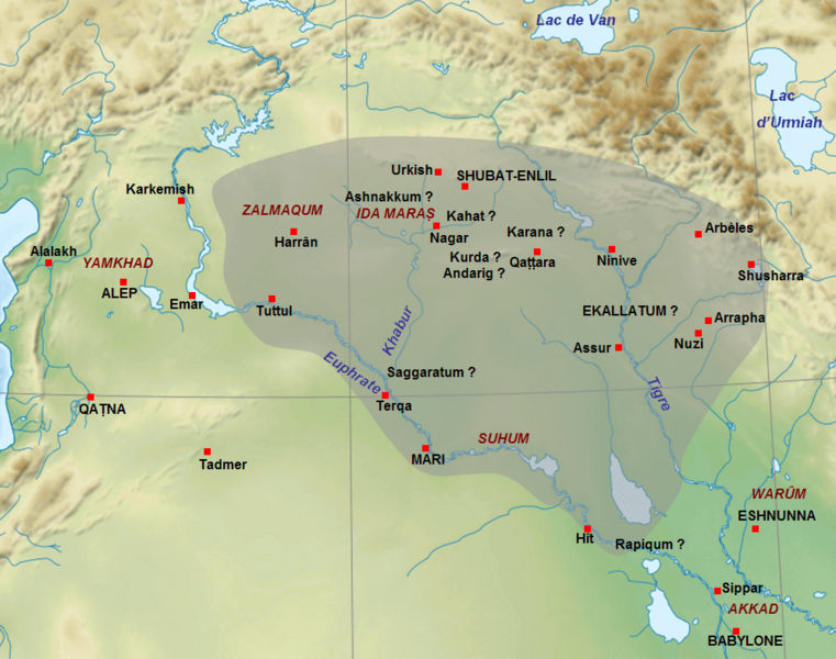
Description: Map of the approximate extension of the kingdom of Samsi-Addu/Shamshi-Adad (1815-1775 BC) just before his death, with the territories given to his sons Ishme-Dagan (around Ekallatum) and Yasmakh-Addu (around Mari). The names of cities in capitals letters are the capitals of the main kingdoms of the Middle East at this time. The names of cities with question mark are for uncertain locations. Adapted from F. Joannès (dir.), Dictionnaire de la civilisation mésopotamienne, Paris, 2001, p. 751 (map by M. Sauvage) and D. Charpin, Hammu-rabi de Babylone, Paris, 2003, p. 306.
Title: Samsi Addu
Credit: Near_East_topographic_map-blank.svg
Author: Near_East_topographic_map-blank.svg: Sémhur derivative work: Zunkir (talk)
Usage Terms: Creative Commons Attribution-Share Alike 3.0
License: CC BY-SA 3.0
License Link: https://creativecommons.org/licenses/by-sa/3.0
Attribution Required?: Yes
Image usage
The following page links to this image:
