
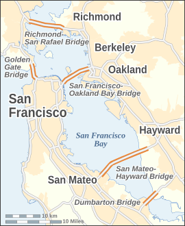
Image: San Francisco Bay Bridges map en

Size of this PNG preview of this SVG file: 270 × 330 pixels. Other resolution: 196 × 240 pixels.
Original image (SVG file, nominally 270 × 330 pixels, file size: 321 KB)
Description: Map of the bridges of San Francisco Bay — in the San Francisco Bay Area, California. Excluding bridges over the Carquinez Straits, which lie to the northeast of this map.
Title: San Francisco Bay Bridges map en
Credit: Own work http://www.census.gov/geo/www/tiger http://www.mtc.ca.gov This vector image was created with Inkscape.
Author: Alexrk
Usage Terms: Creative Commons Attribution-Share Alike 3.0
License: CC BY-SA 3.0
License Link: http://creativecommons.org/licenses/by-sa/3.0
Attribution Required?: Yes
Image usage
The following page links to this image:

All content from Kiddle encyclopedia articles (including the article images and facts) can be freely used under Attribution-ShareAlike license, unless stated otherwise.