
Image: Satellite image of Bir Tawil

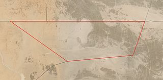
Description: Satellite image of Bir Tawil (highlighted in red), a Terra nullius between Egypt and Sudan. This image is composed of two satellite images, one taken on March 29, and another taken on April 5.
Title: Satellite image of Bir Tawil
Credit: https://worldview.earthdata.nasa.gov/?v=32.55626092826267,21.355252631649694,34.600300491074385,22.35704493821523&l=Reference_Labels(hidden),Reference_Features(hidden),Coastlines(hidden),HLS_L30_Nadir_BRDF_Adjusted_Reflectance,MODIS_Combined_L3_Nadir-BRDF_Daily(hidden),VIIRS_NOAA20_CorrectedReflectance_TrueColor(hidden),VIIRS_SNPP_CorrectedReflectance_TrueColor(hidden),MODIS_Aqua_CorrectedReflectance_TrueColor(hidden),MODIS_Terra_CorrectedReflectance_TrueColor(hidden)&lg=false&t=2021-04-05-T19%3A13%3A59Z
Author: Landsat 8 / OLI
Usage Terms: Public domain
License: Public domain
Attribution Required?: No
Image usage
The following page links to this image:
