
Bir Tawil facts for kids
Quick facts for kids
Bir Tawil
بيرطويل
|
|
|---|---|
| Country | none |
| Area | |
| • Total | 800 sq mi (2,060 km2) |
| Time zone | UTC+2 (EST) |
| • Summer (DST) | +3 |
Bir Tawil (which means "water well" in Arabic) is a small area of land. It covers about 2,060 square kilometers (795 square miles). This area is located right on the border between Egypt and Sudan. What makes Bir Tawil special is that neither country claims it. Because of its shape, it is sometimes called the Bir Tawil Triangle. It is made up of two triangles that meet. The longest side of this area follows the 22nd parallel north, which is a line of latitude.
The political border between Sudan and Egypt was set in 1899. It was decided to be the 22nd parallel north. Bir Tawil lies just south of this line. From east to west, the area is about 46 kilometers (29 miles) long in the south. It stretches to about 95 kilometers (59 miles) long in the north. From north to south, it is between 26 kilometers (16 miles) and 31 kilometers (19 miles) wide.
In 1902, the Bir Tawil area was placed under Egypt's control. This was because it was used as grazing land by the Ababda tribe, who lived near Aswan, Egypt. At the same time, the Hala'ib Triangle, which is north of the 22nd parallel, was put under Sudan's control. This was because the tribes there were closer to Sudan. These two "triangles" touch at one point.
Why is Bir Tawil Unclaimed?
In 1899, an agreement was made between the British, who ruled both Egypt and Sudan at the time. This agreement set the border at the 22nd parallel. However, in 1902, the British drew a different "administrative boundary." This new line put a triangle of land north of the 22nd parallel (the Hala'ib Triangle) under Sudan's control. This was because the people living there were closer to Khartoum (in Sudan) than to Cairo (in Egypt).
- Egypt's Claim: Egypt says the original 1899 border is the correct one. If this is true, the Hala'ib Triangle would belong to Egypt, and Bir Tawil would belong to Sudan.
- Sudan's Claim: Sudan says the 1902 administrative border is the correct one. If this is true, the Hala'ib Triangle would belong to Sudan, and Bir Tawil would belong to Egypt.
Because both countries want the Hala'ib Triangle (which is much larger and more valuable), neither country wants to claim Bir Tawil. If one country claimed Bir Tawil, it would mean they agree to the other country's claim over the Hala'ib Triangle. Since Bir Tawil is much smaller and has no valuable resources, both countries prefer to leave it unclaimed. This makes Bir Tawil one of the very few places on Earth that no country officially claims.
Geography of Bir Tawil
Bir Tawil is mostly a desert area. It has a few interesting natural features:
- Jabal Tawil: In the northern part of the area, there is a mountain called Jabal Tawil. It is about 459 meters (1,506 feet) tall.
- Jabal Ḩajar az Zarqā': To the east, you can find Jabal Ḩajar az Zarqā'. This mountain is taller, reaching about 662 meters (2,172 feet) high.
- Wadi Tawil: In the south, there is a dry riverbed called Wadi Tawil. A "wadi" is a valley or riverbed that is usually dry except during the rainy season.
Images for kids
-
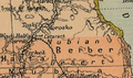
Map of the Hala'ib Triangle and Bir Tawil from 1912
-
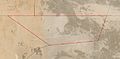
2021 satellite image of Bir Tawil (highlighted in red) by Landsat 8


See also
 In Spanish: Bir Tawil para niños
