
Hala'ib Triangle facts for kids
Quick facts for kids
Hala'ib Triangle
مثلث حلايب
|
|
|---|---|
|
Disputed territory
|
|
 |
|
| Country | Administered by Egypt, claimed by Sudan. |
| Area | |
| • Total | 20,580 km2 (7,950 sq mi) |
| • Disputed area | 20,580 km2 (7,950 sq mi) |
| Lowest elevation | 0 m (0 ft) |
The Hala'ib Triangle (which means "Hala'ib Triangle" in Arabic) is a piece of land on the coast of the Red Sea in Africa. It covers about 20,580 square kilometers (7,946 square miles). This area is named after the town of Hala'ib. Both Egypt and Sudan claim this land, making it a disputed territory.
Contents
Where is the Hala'ib Triangle?
The Hala'ib Triangle is located along the Red Sea coast. It is found where the borders of Egypt and Sudan meet. The area is not actually shaped like a triangle. It is more like a complicated many-sided shape, or a polygon. Only its southern border, which is about 290 kilometers (180 miles) long, is a straight line.
Why is the Hala'ib Triangle Disputed?
The dispute over the Hala'ib Triangle started because of two different borders set by the British. In 1899, when Britain and Egypt ruled Sudan together, they set a "political boundary." This line followed the 22nd parallel north, a straight line of latitude.
However, in 1902, the British made an "administrative boundary." This new border gave the land north of the 22nd parallel to Sudan. This was done to make it easier to manage the local tribes. When Sudan became independent in 1956, both Egypt and Sudan claimed the Hala'ib Triangle based on these different border lines.
Who Controls the Area Now?
Since the 1990s, Egypt has controlled the Hala'ib Triangle. Egypt sent its military into the area during that time. Today, Egypt manages the area as part of its Red Sea Governorate. The Egyptian government has also been investing money and resources into the region.
What is Bir Tawil?
A smaller area called Bir Tawil touches the Hala'ib Triangle at its westernmost point. Bir Tawil is unique because neither Sudan nor Egypt claims it. This is because if either country claimed Bir Tawil, it might weaken their claim to the much larger and more valuable Hala'ib Triangle. So, Bir Tawil remains unclaimed land.
Other Names for the Area
In Egypt, the Hala'ib Triangle is sometimes called the "Sudan Government Administration Area" or SGAA. This name refers to the historical way the area was managed before Egypt took full control.
Images for kids
-
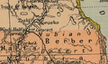
Map of the Halaib Triangle and Bir Tawil from 1912
-
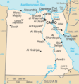
The Halaib Triangle has been under Egyptian administration since mid-1990. This map is colored from the Sudanese perspective
-
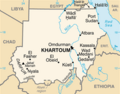
Although this map of Sudan depicts the Halaib Triangle as part of the country, Sudan does not exercise its jurisdiction over the area


See also
 In Spanish: Triángulo de Hala'ib para niños
