
Image: Scientific Investigations Map 2917

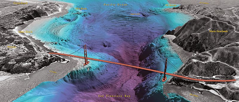
Description: This poster shows views of the sea floor in west-central San Francisco Bay around Alcatraz and Angel Islands, underneath the Golden Gate Bridge, and through its entrance from the Pacific Ocean. The sea floor is portrayed as a shaded relief surface generated from the multibeam data color-coded for depth from light blues for the shallowest values to purples for the deepest. The land regions are portrayed by USGS digital orthophotographs (DOQs) overlaid on USGS digital elevation models (DEMs). The water depths have a 4x vertical exaggeration while the land areas have a 2x vertical exaggeration.
Title: Scientific Investigations Map 2917
Credit: https://pubs.er.usgs.gov/publication/sim2917
Author: Credit: U.S. Geological Survey Department of the Interior/USGS Peter Dartnell ORCID , Patrick L. Barnard , John L. Chin , Daniel Hanes , Rikk G. Kvitek , Pat J. Iampietro , and James V. Gardner
Usage Terms: Public domain
License: Public domain
Attribution Required?: No
Image usage
The following page links to this image:
