
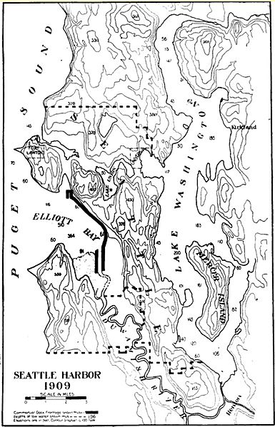
Image: Seattle topo map showing old route of Duwamish River

Size of this preview: 385 × 599 pixels. Other resolutions: 154 × 240 pixels | 984 × 1,531 pixels.
Original image (984 × 1,531 pixels, file size: 308 KB, MIME type: image/jpeg)
Description: Topographical map of Seattle, Washington, 1909, showing the old route of the Duwamish River. Also predates Lake Washington Ship Canal. Original caption: "Seattle Harbor 1909." Compare File:Seattle 1909 harbor improvements proposal on topo.jpg.
Title: Seattle topo map showing old route of Duwamish River
Credit: The Coast magazine, September 1909, Volume XVIII, Number 3, p. 140, accessed on Google Books.
Author: No specific credit for map
Permission: PD-US
Usage Terms: Public domain
License: Public domain
Attribution Required?: No
Image usage
The following page links to this image:

All content from Kiddle encyclopedia articles (including the article images and facts) can be freely used under Attribution-ShareAlike license, unless stated otherwise.