
Image: Siege of Constantinople 1453 map-fr

Size of this PNG preview of this SVG file: 750 × 600 pixels. Other resolution: 300 × 240 pixels.
Original image (SVG file, nominally 2,500 × 2,000 pixels, file size: 184 KB)
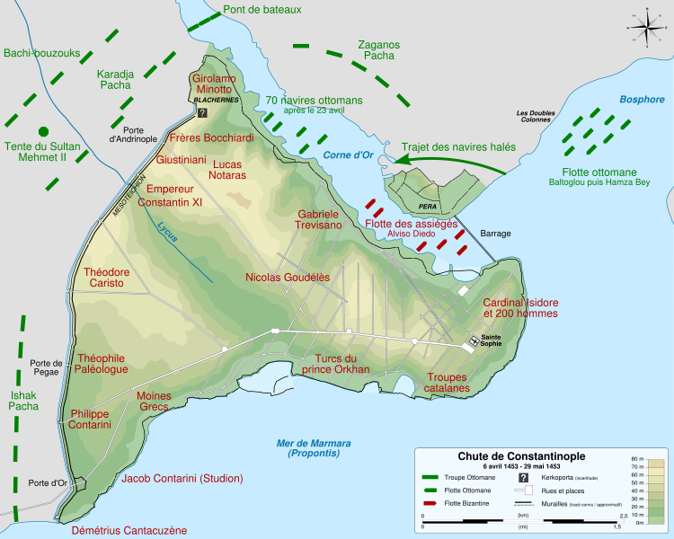
Description: Map of the Ottoman and Byzantine forces during the siege of Constantinople, from 6 April 1453 to 29 May 1453. French version.
Title: Siege of Constantinople 1453 map-fr
Credit: Background: File:Byzantine Constantinople.svg by Cplakidas under licence GFDL or CC-BY-SA 3.0 Disposition of forces: La chute de Constantinople by René Guerdan, Historia N°328 , march 1974. Informations given by Spartan 117
Author: Sémhur (talk)
Usage Terms: Creative Commons Attribution-Share Alike 4.0
License: CC BY-SA 4.0
License Link: https://creativecommons.org/licenses/by-sa/4.0
Attribution Required?: Yes
Image usage
The following page links to this image:

All content from Kiddle encyclopedia articles (including the article images and facts) can be freely used under Attribution-ShareAlike license, unless stated otherwise.